You are here: Home > Network List > TA - USArray Transportable Network (new EarthScope stations) Stations List
> Station J26L Joseph Creek, AK, USA > Earthquake Result Viewer
J26L Joseph Creek, AK, USA - Earthquake Result Viewer
| Earthquake location: |
Negros, Philippines |
| Earthquake latitude/longitude: |
9.4/124.0 |
| Earthquake time(UTC): |
2017/05/20 (140) 01:06:13 GMT |
| Earthquake Depth: |
521 km |
| Earthquake Magnitude: |
5.9 Mww |
| Earthquake Catalog/Contributor: |
NEIC PDE/us |
|
| Network: |
TA USArray Transportable Network (new EarthScope stations) |
| Station: |
J26L Joseph Creek, AK, USA |
| Lat/Lon: |
64.50 N/143.56 W |
| Elevation: |
1144 m |
|
| Distance: |
82.7 deg |
| Az: |
25.851 deg |
| Baz: |
276.269 deg |
| Ray Param: |
0.045227308 |
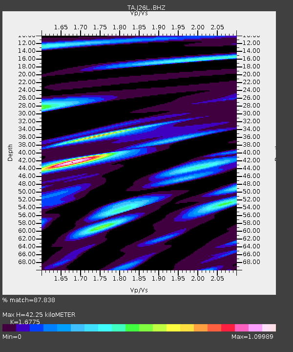
| Estimated Moho Depth: |
42.25 km |
| Estimated Crust Vp/Vs: |
1.68 |
| Assumed Crust Vp: |
6.566 km/s |
| Estimated Crust Vs: |
3.914 km/s |
| Estimated Crust Poisson's Ratio: |
0.22 |
|
| Radial Match: |
87.838 % |
| Radial Bump: |
400 |
| Transverse Match: |
72.78957 % |
| Transverse Bump: |
400 |
| SOD ConfigId: |
13570011 |
| Insert Time: |
2019-04-28 01:29:56.928 +0000 |
| GWidth: |
2.5 |
| Max Bumps: |
400 |
| Tol: |
0.001 |
|
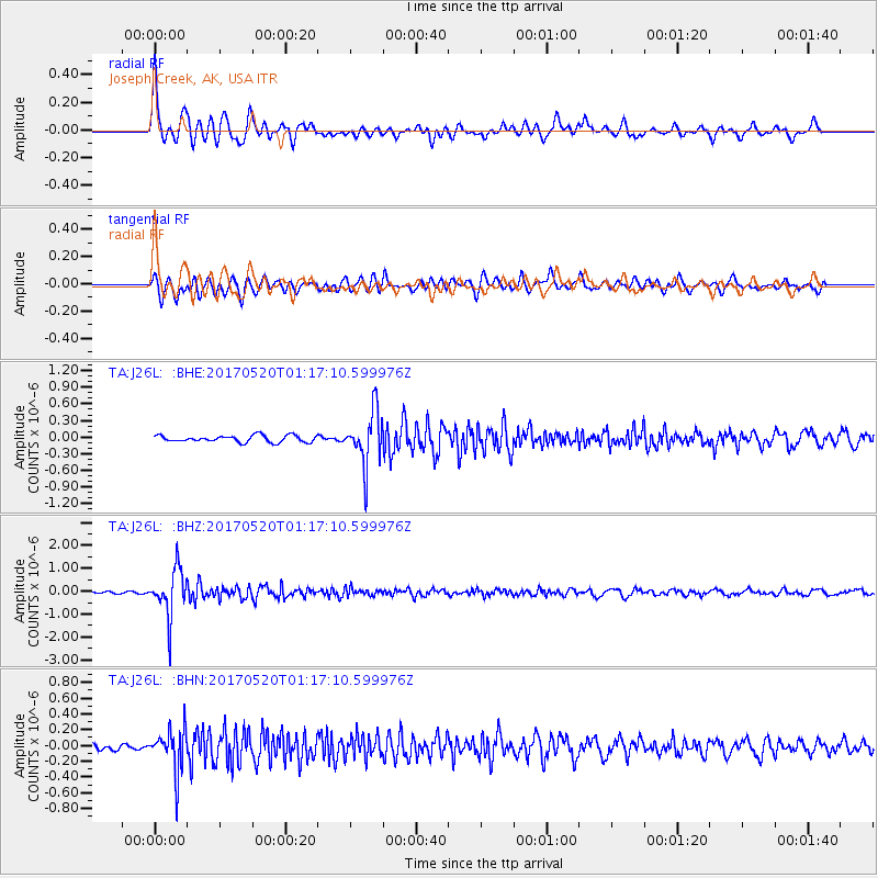
Signal To Noise
| Channel | StoN | STA | LTA |
| TA:J26L: :BHZ:20170520T01:17:10.599976Z | 20.042913 | 1.0368371E-6 | 5.173086E-8 |
| TA:J26L: :BHN:20170520T01:17:10.599976Z | 3.9204767 | 2.7650313E-7 | 7.052793E-8 |
| TA:J26L: :BHE:20170520T01:17:10.599976Z | 7.9690976 | 4.7909606E-7 | 6.0119234E-8 |
| Arrivals |
| Ps | 4.5 SECOND |
| PpPs | 17 SECOND |
| PsPs/PpSs | 21 SECOND |


