You are here: Home > Network List > TA - USArray Transportable Network (new EarthScope stations) Stations List
> Station R17K Ugashik Creek, AK, USA > Earthquake Result Viewer
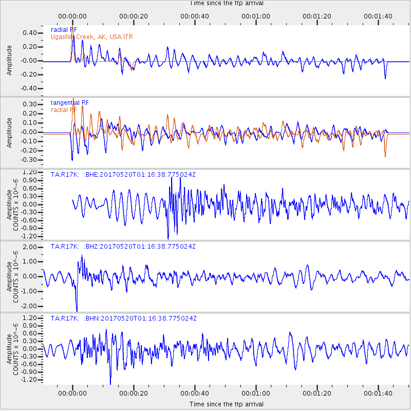
R17K Ugashik Creek, AK, USA - Earthquake Result Viewer
*The percent match for this event was below the threshold and hence no stack was calculated.
| Earthquake location: |
Negros, Philippines |
| Earthquake latitude/longitude: |
9.4/124.0 |
| Earthquake time(UTC): |
2017/05/20 (140) 01:06:13 GMT |
| Earthquake Depth: |
521 km |
| Earthquake Magnitude: |
5.9 Mww |
| Earthquake Catalog/Contributor: |
NEIC PDE/us |
|
| Network: |
TA USArray Transportable Network (new EarthScope stations) |
| Station: |
R17K Ugashik Creek, AK, USA |
| Lat/Lon: |
57.64 N/156.39 W |
| Elevation: |
273 m |
|
| Distance: |
76.6 deg |
| Az: |
32.949 deg |
| Baz: |
266.315 deg |
| Ray Param: |
$rayparam |
*The percent match for this event was below the threshold and hence was not used in the summary stack. |
|
| Radial Match: |
56.299625 % |
| Radial Bump: |
400 |
| Transverse Match: |
62.344025 % |
| Transverse Bump: |
400 |
| SOD ConfigId: |
13570011 |
| Insert Time: |
2019-04-28 01:30:43.193 +0000 |
| GWidth: |
2.5 |
| Max Bumps: |
400 |
| Tol: |
0.001 |
|
Signal To Noise
| Channel | StoN | STA | LTA |
| TA:R17K: :BHZ:20170520T01:16:38.775024Z | 2.840063 | 8.451921E-7 | 2.9759624E-7 |
| TA:R17K: :BHN:20170520T01:16:38.775024Z | 1.6829116 | 2.7706145E-7 | 1.646322E-7 |
| TA:R17K: :BHE:20170520T01:16:38.775024Z | 1.6313642 | 5.185368E-7 | 3.1785473E-7 |
| Arrivals |
| Ps | |
| PpPs | |
| PsPs/PpSs | |


