You are here: Home > Network List > TA - USArray Transportable Network (new EarthScope stations) Stations List
> Station R33M Jennings River, BC, CAN > Earthquake Result Viewer
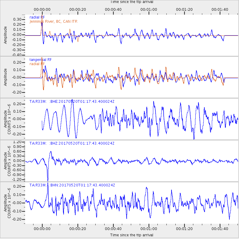
R33M Jennings River, BC, CAN - Earthquake Result Viewer
*The percent match for this event was below the threshold and hence no stack was calculated.
| Earthquake location: |
Negros, Philippines |
| Earthquake latitude/longitude: |
9.4/124.0 |
| Earthquake time(UTC): |
2017/05/20 (140) 01:06:13 GMT |
| Earthquake Depth: |
521 km |
| Earthquake Magnitude: |
5.9 Mww |
| Earthquake Catalog/Contributor: |
NEIC PDE/us |
|
| Network: |
TA USArray Transportable Network (new EarthScope stations) |
| Station: |
R33M Jennings River, BC, CAN |
| Lat/Lon: |
59.39 N/130.97 W |
| Elevation: |
1437 m |
|
| Distance: |
89.5 deg |
| Az: |
29.611 deg |
| Baz: |
287.647 deg |
| Ray Param: |
$rayparam |
*The percent match for this event was below the threshold and hence was not used in the summary stack. |
|
| Radial Match: |
60.361897 % |
| Radial Bump: |
400 |
| Transverse Match: |
47.11634 % |
| Transverse Bump: |
400 |
| SOD ConfigId: |
13570011 |
| Insert Time: |
2019-04-28 01:30:44.061 +0000 |
| GWidth: |
2.5 |
| Max Bumps: |
400 |
| Tol: |
0.001 |
|
Signal To Noise
| Channel | StoN | STA | LTA |
| TA:R33M: :BHZ:20170520T01:17:43.400024Z | 9.730393 | 4.3574403E-7 | 4.4781746E-8 |
| TA:R33M: :BHN:20170520T01:17:43.400024Z | 1.8373625 | 8.0422815E-8 | 4.3770793E-8 |
| TA:R33M: :BHE:20170520T01:17:43.400024Z | 0.74149543 | 9.131449E-8 | 1.2314909E-7 |
| Arrivals |
| Ps | |
| PpPs | |
| PsPs/PpSs | |


