You are here: Home > Network List > TA - USArray Transportable Network (new EarthScope stations) Stations List
> Station 431A Sonora, TX, USA > Earthquake Result Viewer
431A Sonora, TX, USA - Earthquake Result Viewer

| Earthquake location: |
Kuril Islands |
| Earthquake latitude/longitude: |
48.3/154.2 |
| Earthquake time(UTC): |
2009/09/10 (253) 02:46:50 GMT |
| Earthquake Depth: |
36 km |
| Earthquake Magnitude: |
6.0 MB, 5.5 MS, 6.0 MW, 5.8 MW |
| Earthquake Catalog/Contributor: |
WHDF/NEIC |
|
| Network: |
TA USArray Transportable Network (new EarthScope stations) |
| Station: |
431A Sonora, TX, USA |
| Lat/Lon: |
30.68 N/100.61 W |
| Elevation: |
700 m |
|
| Distance: |
76.9 deg |
| Az: |
58.618 deg |
| Baz: |
318.589 deg |
| Ray Param: |
0.050656248 |
| Estimated Moho Depth: |
25.75 km |
| Estimated Crust Vp/Vs: |
2.09 |
| Assumed Crust Vp: |
6.38 km/s |
| Estimated Crust Vs: |
3.057 km/s |
| Estimated Crust Poisson's Ratio: |
0.35 |
|
| Radial Match: |
80.47071 % |
| Radial Bump: |
355 |
| Transverse Match: |
80.21935 % |
| Transverse Bump: |
400 |
| SOD ConfigId: |
2622 |
| Insert Time: |
2010-03-05 23:57:12.188 +0000 |
| GWidth: |
2.5 |
| Max Bumps: |
400 |
| Tol: |
0.001 |
|
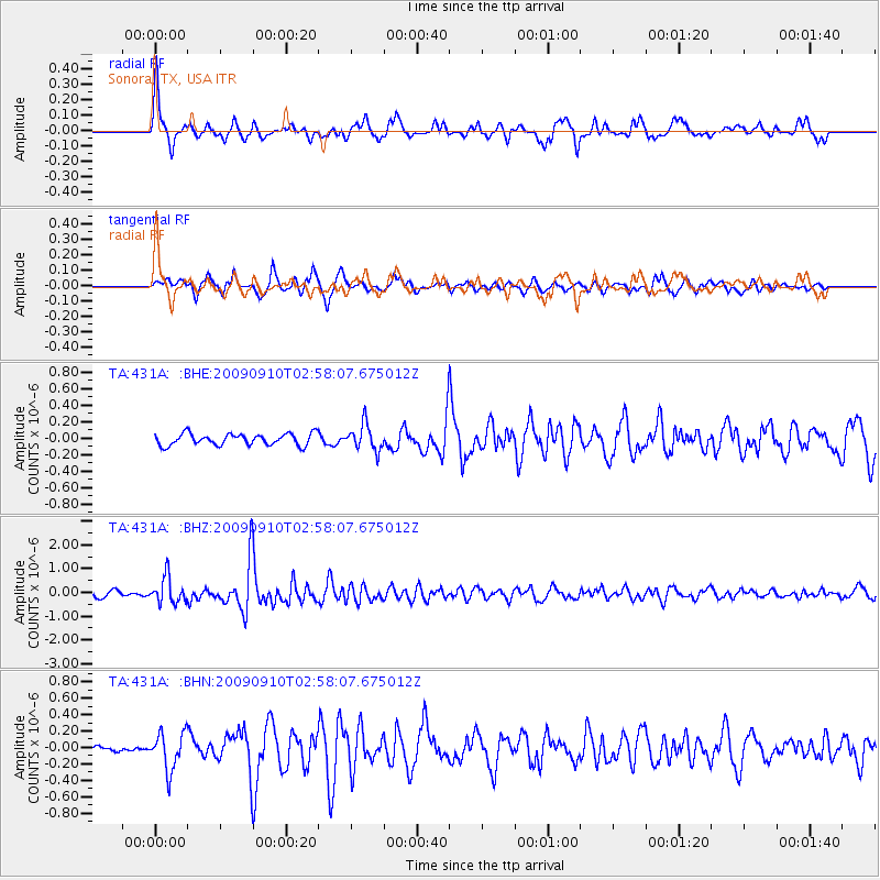
Signal To Noise
| Channel | StoN | STA | LTA |
| TA:431A: :BHZ:20090910T02:58:07.675012Z | 5.077421 | 5.46473E-7 | 1.0762807E-7 |
| TA:431A: :BHN:20090910T02:58:07.675012Z | 2.939739 | 2.2625534E-7 | 7.6964426E-8 |
| TA:431A: :BHE:20090910T02:58:07.675012Z | 2.2549658 | 1.5770331E-7 | 6.9936014E-8 |
| Arrivals |
| Ps | 4.5 SECOND |
| PpPs | 12 SECOND |
| PsPs/PpSs | 17 SECOND |


