You are here: Home > Network List > TA - USArray Transportable Network (new EarthScope stations) Stations List
> Station 431A Sonora, TX, USA > Earthquake Result Viewer
431A Sonora, TX, USA - Earthquake Result Viewer
| Earthquake location: |
Samoa Islands Region |
| Earthquake latitude/longitude: |
-16.2/-173.0 |
| Earthquake time(UTC): |
2009/09/29 (272) 18:21:42 GMT |
| Earthquake Depth: |
10 km |
| Earthquake Magnitude: |
5.8 MB |
| Earthquake Catalog/Contributor: |
WHDF/NEIC |
|
| Network: |
TA USArray Transportable Network (new EarthScope stations) |
| Station: |
431A Sonora, TX, USA |
| Lat/Lon: |
30.68 N/100.61 W |
| Elevation: |
700 m |
|
| Distance: |
83.7 deg |
| Az: |
55.694 deg |
| Baz: |
247.103 deg |
| Ray Param: |
0.04600761 |
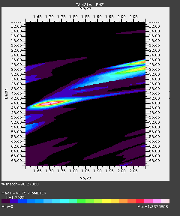
| Estimated Moho Depth: |
43.75 km |
| Estimated Crust Vp/Vs: |
1.70 |
| Assumed Crust Vp: |
6.38 km/s |
| Estimated Crust Vs: |
3.748 km/s |
| Estimated Crust Poisson's Ratio: |
0.24 |
|
| Radial Match: |
90.27868 % |
| Radial Bump: |
400 |
| Transverse Match: |
58.2722 % |
| Transverse Bump: |
400 |
| SOD ConfigId: |
2622 |
| Insert Time: |
2010-03-05 23:57:17.917 +0000 |
| GWidth: |
2.5 |
| Max Bumps: |
400 |
| Tol: |
0.001 |
|
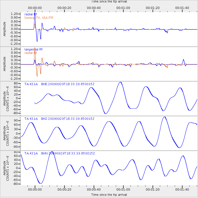
Signal To Noise
| Channel | StoN | STA | LTA |
| TA:431A: :BHZ:20090929T18:33:39.850015Z | 1.596528 | 3.8217942E-5 | 2.3938159E-5 |
| TA:431A: :BHN:20090929T18:33:39.850015Z | 1.7667955 | 6.0865408E-5 | 3.4449607E-5 |
| TA:431A: :BHE:20090929T18:33:39.850015Z | 1.3879399 | 2.2912103E-5 | 1.6507993E-5 |
| Arrivals |
| Ps | 4.9 SECOND |
| PpPs | 18 SECOND |
| PsPs/PpSs | 23 SECOND |


