You are here: Home > Network List > TA - USArray Transportable Network (new EarthScope stations) Stations List
> Station 431A Sonora, TX, USA > Earthquake Result Viewer
431A Sonora, TX, USA - Earthquake Result Viewer
| Earthquake location: |
Tonga Islands |
| Earthquake latitude/longitude: |
-16.3/-173.5 |
| Earthquake time(UTC): |
2009/10/02 (275) 01:07:39 GMT |
| Earthquake Depth: |
8.0 km |
| Earthquake Magnitude: |
6.1 MB, 6.0 MS, 6.1 MW, 6.1 MW |
| Earthquake Catalog/Contributor: |
WHDF/NEIC |
|
| Network: |
TA USArray Transportable Network (new EarthScope stations) |
| Station: |
431A Sonora, TX, USA |
| Lat/Lon: |
30.68 N/100.61 W |
| Elevation: |
700 m |
|
| Distance: |
84.2 deg |
| Az: |
55.849 deg |
| Baz: |
247.266 deg |
| Ray Param: |
0.04568383 |
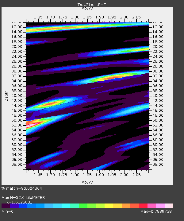
| Estimated Moho Depth: |
52.0 km |
| Estimated Crust Vp/Vs: |
1.61 |
| Assumed Crust Vp: |
6.38 km/s |
| Estimated Crust Vs: |
3.957 km/s |
| Estimated Crust Poisson's Ratio: |
0.19 |
|
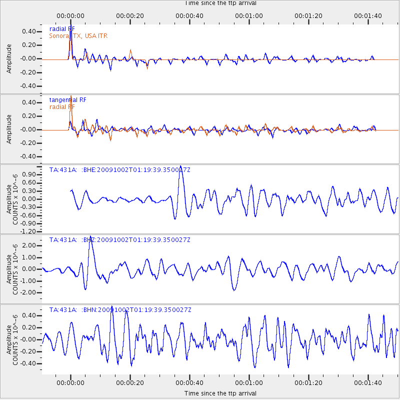
| Radial Match: |
90.004364 % |
| Radial Bump: |
399 |
| Transverse Match: |
61.916977 % |
| Transverse Bump: |
340 |
| SOD ConfigId: |
2622 |
| Insert Time: |
2010-03-05 23:57:19.319 +0000 |
| GWidth: |
2.5 |
| Max Bumps: |
400 |
| Tol: |
0.001 |
|
Signal To Noise
| Channel | StoN | STA | LTA |
| TA:431A: :BHZ:20091002T01:19:39.350027Z | 4.2601013 | 5.373692E-7 | 1.2614001E-7 |
| TA:431A: :BHN:20091002T01:19:39.350027Z | 1.7946266 | 1.8402943E-7 | 1.02544696E-7 |
| TA:431A: :BHE:20091002T01:19:39.350027Z | 1.2077904 | 1.6448996E-7 | 1.3619082E-7 |
| Arrivals |
| Ps | 5.1 SECOND |
| PpPs | 21 SECOND |
| PsPs/PpSs | 26 SECOND |


