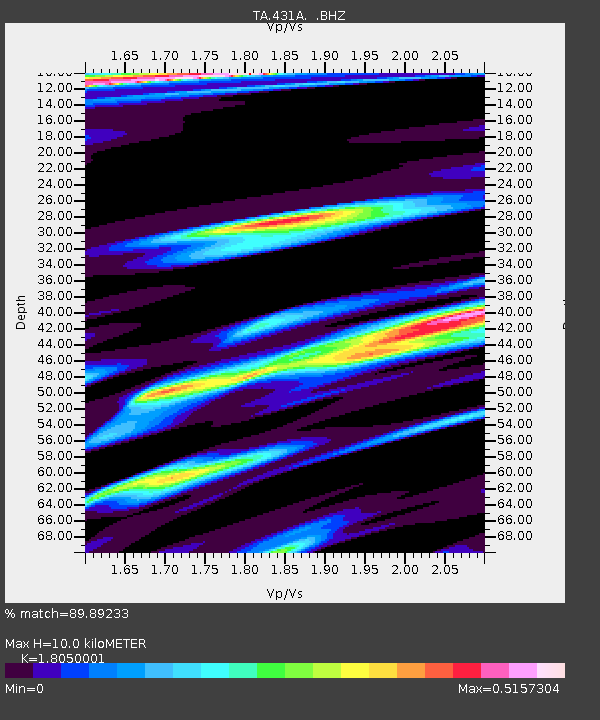
431A Sonora, TX, USA - Earthquake Result Viewer
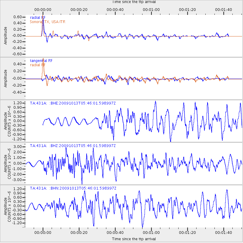
Earthquake location: Fox Islands, Aleutian Islands
Earthquake latitude/longitude: 52.8/-167.0
Earthquake time(UTC): 2009/10/13 (286) 05:37:23 GMT
Earthquake Depth: 24 km
Earthquake Magnitude: 6.0 MB, 6.1 MS, 6.5 MW, 6.5 MW
Earthquake Catalog/Contributor: WHDF/NEIC
Network: TA USArray Transportable Network (new EarthScope stations)
Station: 431A Sonora, TX, USA
Lat/Lon: 30.68 N/100.61 W
Elevation: 700 m
Distance: 52.2 deg
Az: 87.489 deg
Baz: 315.183 deg
Ray Param: 0.06687673
Estimated Moho Depth: 10.0 km
Estimated Crust Vp/Vs: 1.81
Assumed Crust Vp: 6.38 km/s
Estimated Crust Vs: 3.535 km/s
Estimated Crust Poisson's Ratio: 0.28
Radial Match: 89.89233 %
Radial Bump: 400
Transverse Match: 81.11441 %
Transverse Bump: 400
SOD ConfigId: 2622
Insert Time: 2010-03-05 23:57:22.842 +0000
GWidth: 2.5
Max Bumps: 400
Tol: 0.001

Signal To Noise

ChannelStoNSTALTA
TA:431A: :BHZ:20091013T05:46:01.598997Z4.698217.9908034E-71.7008188E-7
TA:431A: :BHN:20091013T05:46:01.598997Z1.06957261.4722153E-71.376452E-7
TA:431A: :BHE:20091013T05:46:01.598997Z1.71003032.9048937E-71.6987381E-7
Arrivals
Ps1.3 SECOND
PpPs4.2 SECOND
PsPs/PpSs5.5 SECOND