You are here: Home > Network List > TA - USArray Transportable Network (new EarthScope stations) Stations List
> Station 431A Sonora, TX, USA > Earthquake Result Viewer
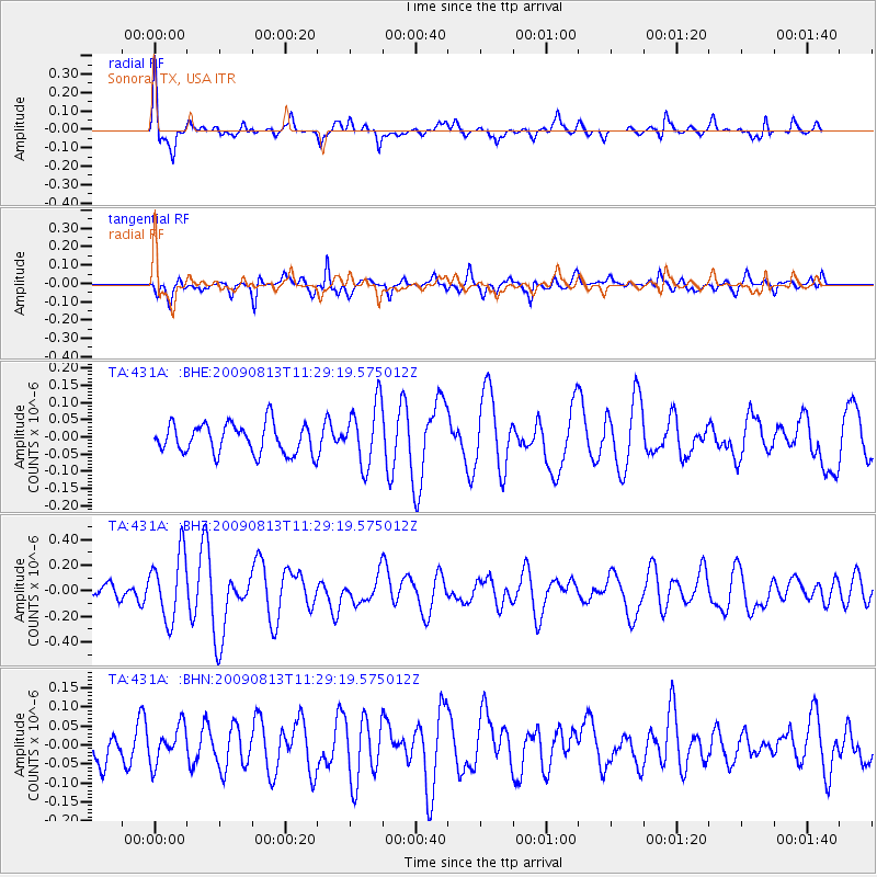
431A Sonora, TX, USA - Earthquake Result Viewer
*The percent match for this event was below the threshold and hence no stack was calculated.
| Earthquake location: |
Tonga Islands |
| Earthquake latitude/longitude: |
-21.7/-174.6 |
| Earthquake time(UTC): |
2009/08/13 (225) 11:17:01 GMT |
| Earthquake Depth: |
10 km |
| Earthquake Magnitude: |
5.6 MW, 5.3 MB |
| Earthquake Catalog/Contributor: |
WHDF/NEIC |
|
| Network: |
TA USArray Transportable Network (new EarthScope stations) |
| Station: |
431A Sonora, TX, USA |
| Lat/Lon: |
30.68 N/100.61 W |
| Elevation: |
700 m |
|
| Distance: |
88.0 deg |
| Az: |
55.942 deg |
| Baz: |
243.45 deg |
| Ray Param: |
$rayparam |
*The percent match for this event was below the threshold and hence was not used in the summary stack. |
|
| Radial Match: |
79.37787 % |
| Radial Bump: |
280 |
| Transverse Match: |
61.91051 % |
| Transverse Bump: |
400 |
| SOD ConfigId: |
2622 |
| Insert Time: |
2010-03-05 23:57:51.133 +0000 |
| GWidth: |
2.5 |
| Max Bumps: |
400 |
| Tol: |
0.001 |
|
Signal To Noise
| Channel | StoN | STA | LTA |
| TA:431A: :BHZ:20090813T11:29:19.575012Z | 4.751627 | 2.582544E-7 | 5.435073E-8 |
| TA:431A: :BHN:20090813T11:29:19.575012Z | 0.8919093 | 4.7906926E-8 | 5.371278E-8 |
| TA:431A: :BHE:20090813T11:29:19.575012Z | 2.0808449 | 8.981548E-8 | 4.3162984E-8 |
| Arrivals |
| Ps | |
| PpPs | |
| PsPs/PpSs | |


