You are here: Home > Network List > TA - USArray Transportable Network (new EarthScope stations) Stations List
> Station 431A Sonora, TX, USA > Earthquake Result Viewer
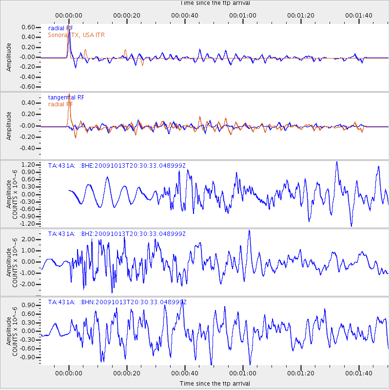
431A Sonora, TX, USA - Earthquake Result Viewer
*The percent match for this event was below the threshold and hence no stack was calculated.
| Earthquake location: |
Fox Islands, Aleutian Islands |
| Earthquake latitude/longitude: |
52.6/-167.1 |
| Earthquake time(UTC): |
2009/10/13 (286) 20:21:53 GMT |
| Earthquake Depth: |
14 km |
| Earthquake Magnitude: |
5.9 MB, 6.4 MS, 6.4 MW, 6.4 MW |
| Earthquake Catalog/Contributor: |
WHDF/NEIC |
|
| Network: |
TA USArray Transportable Network (new EarthScope stations) |
| Station: |
431A Sonora, TX, USA |
| Lat/Lon: |
30.68 N/100.61 W |
| Elevation: |
700 m |
|
| Distance: |
52.3 deg |
| Az: |
87.28 deg |
| Baz: |
314.997 deg |
| Ray Param: |
$rayparam |
*The percent match for this event was below the threshold and hence was not used in the summary stack. |
|
| Radial Match: |
78.41446 % |
| Radial Bump: |
385 |
| Transverse Match: |
59.823757 % |
| Transverse Bump: |
400 |
| SOD ConfigId: |
2622 |
| Insert Time: |
2010-03-05 23:58:03.727 +0000 |
| GWidth: |
2.5 |
| Max Bumps: |
400 |
| Tol: |
0.001 |
|
Signal To Noise
| Channel | StoN | STA | LTA |
| TA:431A: :BHZ:20091013T20:30:33.048999Z | 1.68632 | 5.442882E-7 | 3.2276685E-7 |
| TA:431A: :BHN:20091013T20:30:33.048999Z | 0.742058 | 2.1043223E-7 | 2.8357923E-7 |
| TA:431A: :BHE:20091013T20:30:33.048999Z | 0.50478935 | 1.5543324E-7 | 3.0791705E-7 |
| Arrivals |
| Ps | |
| PpPs | |
| PsPs/PpSs | |


