You are here: Home > Network List > TA - USArray Transportable Network (new EarthScope stations) Stations List
> Station 431A Sonora, TX, USA > Earthquake Result Viewer
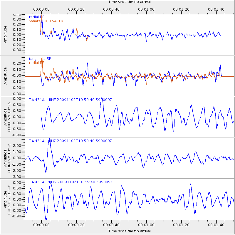
431A Sonora, TX, USA - Earthquake Result Viewer
*The percent match for this event was below the threshold and hence no stack was calculated.
| Earthquake location: |
South Of Tonga Islands |
| Earthquake latitude/longitude: |
-24.1/-175.2 |
| Earthquake time(UTC): |
2009/11/02 (306) 10:47:13 GMT |
| Earthquake Depth: |
9.0 km |
| Earthquake Magnitude: |
6.1 MB, 6.1 MS, 6.2 MW, 6.1 MW |
| Earthquake Catalog/Contributor: |
WHDF/NEIC |
|
| Network: |
TA USArray Transportable Network (new EarthScope stations) |
| Station: |
431A Sonora, TX, USA |
| Lat/Lon: |
30.68 N/100.61 W |
| Elevation: |
700 m |
|
| Distance: |
89.8 deg |
| Az: |
56.144 deg |
| Baz: |
241.733 deg |
| Ray Param: |
$rayparam |
*The percent match for this event was below the threshold and hence was not used in the summary stack. |
|
| Radial Match: |
78.77737 % |
| Radial Bump: |
400 |
| Transverse Match: |
58.480312 % |
| Transverse Bump: |
339 |
| SOD ConfigId: |
2622 |
| Insert Time: |
2010-03-05 23:58:12.810 +0000 |
| GWidth: |
2.5 |
| Max Bumps: |
400 |
| Tol: |
0.001 |
|
Signal To Noise
| Channel | StoN | STA | LTA |
| TA:431A: :BHZ:20091102T10:59:40.599009Z | 9.914291 | 1.5923501E-6 | 1.6061159E-7 |
| TA:431A: :BHN:20091102T10:59:40.599009Z | 2.1121318 | 6.236203E-7 | 2.952563E-7 |
| TA:431A: :BHE:20091102T10:59:40.599009Z | 2.2529504 | 4.9773763E-7 | 2.2092705E-7 |
| Arrivals |
| Ps | |
| PpPs | |
| PsPs/PpSs | |


