You are here: Home > Network List > TA - USArray Transportable Network (new EarthScope stations) Stations List
> Station 431A Sonora, TX, USA > Earthquake Result Viewer
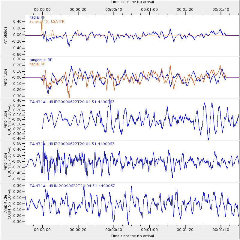
431A Sonora, TX, USA - Earthquake Result Viewer
*The percent match for this event was below the threshold and hence no stack was calculated.
| Earthquake location: |
Andreanof Islands, Aleutian Is. |
| Earthquake latitude/longitude: |
51.3/-178.2 |
| Earthquake time(UTC): |
2009/06/22 (173) 19:55:24 GMT |
| Earthquake Depth: |
35 km |
| Earthquake Magnitude: |
5.6 MB, 5.6 MW, 5.6 MW |
| Earthquake Catalog/Contributor: |
WHDF/NEIC |
|
| Network: |
TA USArray Transportable Network (new EarthScope stations) |
| Station: |
431A Sonora, TX, USA |
| Lat/Lon: |
30.68 N/100.61 W |
| Elevation: |
700 m |
|
| Distance: |
59.2 deg |
| Az: |
78.258 deg |
| Baz: |
314.453 deg |
| Ray Param: |
$rayparam |
*The percent match for this event was below the threshold and hence was not used in the summary stack. |
|
| Radial Match: |
44.684483 % |
| Radial Bump: |
400 |
| Transverse Match: |
56.008945 % |
| Transverse Bump: |
400 |
| SOD ConfigId: |
2648 |
| Insert Time: |
2010-03-05 23:58:17.829 +0000 |
| GWidth: |
2.5 |
| Max Bumps: |
400 |
| Tol: |
0.001 |
|
Signal To Noise
| Channel | StoN | STA | LTA |
| TA:431A: :BHZ:20090622T20:04:51.449006Z | 2.2413 | 2.897175E-7 | 1.2926314E-7 |
| TA:431A: :BHN:20090622T20:04:51.449006Z | 1.3925371 | 1.2741882E-7 | 9.150119E-8 |
| TA:431A: :BHE:20090622T20:04:51.449006Z | 1.1033657 | 1.08417574E-7 | 9.8260784E-8 |
| Arrivals |
| Ps | |
| PpPs | |
| PsPs/PpSs | |


