You are here: Home > Network List > TA - USArray Transportable Network (new EarthScope stations) Stations List
> Station 431A Sonora, TX, USA > Earthquake Result Viewer
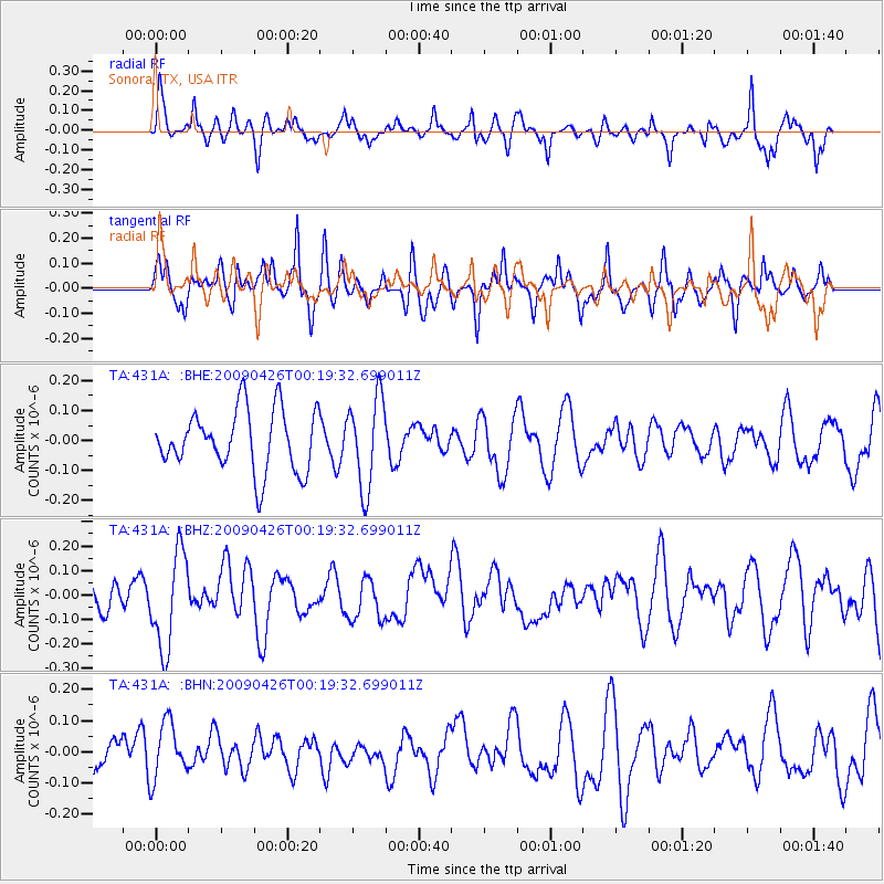
431A Sonora, TX, USA - Earthquake Result Viewer
*The percent match for this event was below the threshold and hence no stack was calculated.
| Earthquake location: |
Kermadec Islands, New Zealand |
| Earthquake latitude/longitude: |
-30.3/-178.6 |
| Earthquake time(UTC): |
2009/04/26 (116) 00:06:53 GMT |
| Earthquake Depth: |
132 km |
| Earthquake Magnitude: |
5.5 MB, 6.1 MW, 6.1 MW |
| Earthquake Catalog/Contributor: |
WHDF/NEIC |
|
| Network: |
TA USArray Transportable Network (new EarthScope stations) |
| Station: |
431A Sonora, TX, USA |
| Lat/Lon: |
30.68 N/100.61 W |
| Elevation: |
700 m |
|
| Distance: |
95.7 deg |
| Az: |
57.867 deg |
| Baz: |
238.224 deg |
| Ray Param: |
$rayparam |
*The percent match for this event was below the threshold and hence was not used in the summary stack. |
|
| Radial Match: |
66.111176 % |
| Radial Bump: |
400 |
| Transverse Match: |
63.10177 % |
| Transverse Bump: |
400 |
| SOD ConfigId: |
2658 |
| Insert Time: |
2010-03-05 23:58:21.121 +0000 |
| GWidth: |
2.5 |
| Max Bumps: |
400 |
| Tol: |
0.001 |
|
Signal To Noise
| Channel | StoN | STA | LTA |
| TA:431A: :BHZ:20090426T00:19:32.699011Z | 2.3968003 | 1.9675272E-7 | 8.208974E-8 |
| TA:431A: :BHN:20090426T00:19:32.699011Z | 1.5996885 | 9.065353E-8 | 5.666949E-8 |
| TA:431A: :BHE:20090426T00:19:32.699011Z | 1.4927381 | 1.5007069E-7 | 1.0053383E-7 |
| Arrivals |
| Ps | |
| PpPs | |
| PsPs/PpSs | |


