You are here: Home > Network List > N4 - Central and EAstern US Network Stations List
> Station T59A Double 'B' Farms, VA, USA > Earthquake Result Viewer
T59A Double 'B' Farms, VA, USA - Earthquake Result Viewer
| Earthquake location: |
Off Coast Of Jalisco, Mexico |
| Earthquake latitude/longitude: |
17.4/-105.4 |
| Earthquake time(UTC): |
2017/05/20 (140) 06:02:13 GMT |
| Earthquake Depth: |
10 km |
| Earthquake Magnitude: |
5.8 Mww |
| Earthquake Catalog/Contributor: |
NEIC PDE/us |
|
| Network: |
N4 Central and EAstern US Network |
| Station: |
T59A Double 'B' Farms, VA, USA |
| Lat/Lon: |
36.97 N/77.55 W |
| Elevation: |
63 m |
|
| Distance: |
31.3 deg |
| Az: |
46.002 deg |
| Baz: |
239.037 deg |
| Ray Param: |
0.07910727 |
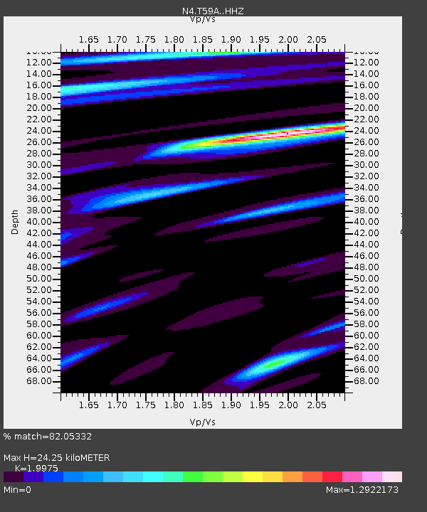
| Estimated Moho Depth: |
24.25 km |
| Estimated Crust Vp/Vs: |
2.00 |
| Assumed Crust Vp: |
6.565 km/s |
| Estimated Crust Vs: |
3.286 km/s |
| Estimated Crust Poisson's Ratio: |
0.33 |
|
| Radial Match: |
82.05332 % |
| Radial Bump: |
400 |
| Transverse Match: |
49.96431 % |
| Transverse Bump: |
400 |
| SOD ConfigId: |
13570011 |
| Insert Time: |
2019-04-28 01:35:24.372 +0000 |
| GWidth: |
2.5 |
| Max Bumps: |
400 |
| Tol: |
0.001 |
|

Signal To Noise
| Channel | StoN | STA | LTA |
| N4:T59A: :HHZ:20170520T06:08:03.109993Z | 4.995845 | 2.8272214E-7 | 5.6591457E-8 |
| N4:T59A: :HHN:20170520T06:08:03.109993Z | 1.6737119 | 7.271146E-8 | 4.3443237E-8 |
| N4:T59A: :HHE:20170520T06:08:03.109993Z | 2.8810654 | 1.3873783E-7 | 4.8155044E-8 |
| Arrivals |
| Ps | 4.0 SECOND |
| PpPs | 10 SECOND |
| PsPs/PpSs | 14 SECOND |


