You are here: Home > Network List > TA - USArray Transportable Network (new EarthScope stations) Stations List
> Station T22A Edith, CO, USA > Earthquake Result Viewer
T22A Edith, CO, USA - Earthquake Result Viewer
| Earthquake location: |
Central Mid-Atlantic Ridge |
| Earthquake latitude/longitude: |
7.3/-34.9 |
| Earthquake time(UTC): |
2008/05/23 (144) 19:35:34 GMT |
| Earthquake Depth: |
9.0 km |
| Earthquake Magnitude: |
6.0 MB, 6.4 MS, 6.5 MW, 6.5 MW |
| Earthquake Catalog/Contributor: |
WHDF/NEIC |
|
| Network: |
TA USArray Transportable Network (new EarthScope stations) |
| Station: |
T22A Edith, CO, USA |
| Lat/Lon: |
37.01 N/106.90 W |
| Elevation: |
2224 m |
|
| Distance: |
71.3 deg |
| Az: |
306.502 deg |
| Baz: |
94.996 deg |
| Ray Param: |
0.054440204 |
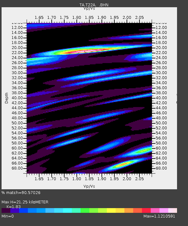
| Estimated Moho Depth: |
21.25 km |
| Estimated Crust Vp/Vs: |
1.83 |
| Assumed Crust Vp: |
6.159 km/s |
| Estimated Crust Vs: |
3.365 km/s |
| Estimated Crust Poisson's Ratio: |
0.29 |
|
| Radial Match: |
90.57026 % |
| Radial Bump: |
400 |
| Transverse Match: |
59.383614 % |
| Transverse Bump: |
400 |
| SOD ConfigId: |
2504 |
| Insert Time: |
2010-03-05 23:58:42.082 +0000 |
| GWidth: |
2.5 |
| Max Bumps: |
400 |
| Tol: |
0.001 |
|
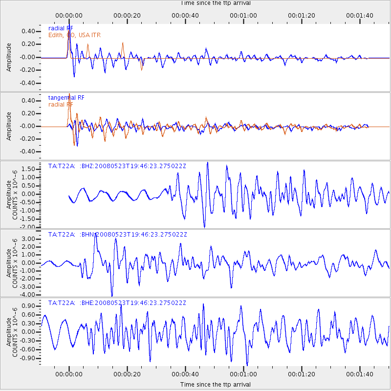
Signal To Noise
| Channel | StoN | STA | LTA |
| TA:T22A: :BHN:20080523T19:46:23.275022Z | 2.3491383 | 5.4723546E-7 | 2.3295158E-7 |
| TA:T22A: :BHE:20080523T19:46:23.275022Z | 0.8151447 | 2.8061288E-7 | 3.4424917E-7 |
| TA:T22A: :BHZ:20080523T19:46:23.275022Z | 1.1301183 | 2.6570618E-7 | 2.3511359E-7 |
| Arrivals |
| Ps | 3.0 SECOND |
| PpPs | 9.5 SECOND |
| PsPs/PpSs | 12 SECOND |


