You are here: Home > Network List > TA - USArray Transportable Network (new EarthScope stations) Stations List
> Station J20K Nowitna River, AK, USA > Earthquake Result Viewer
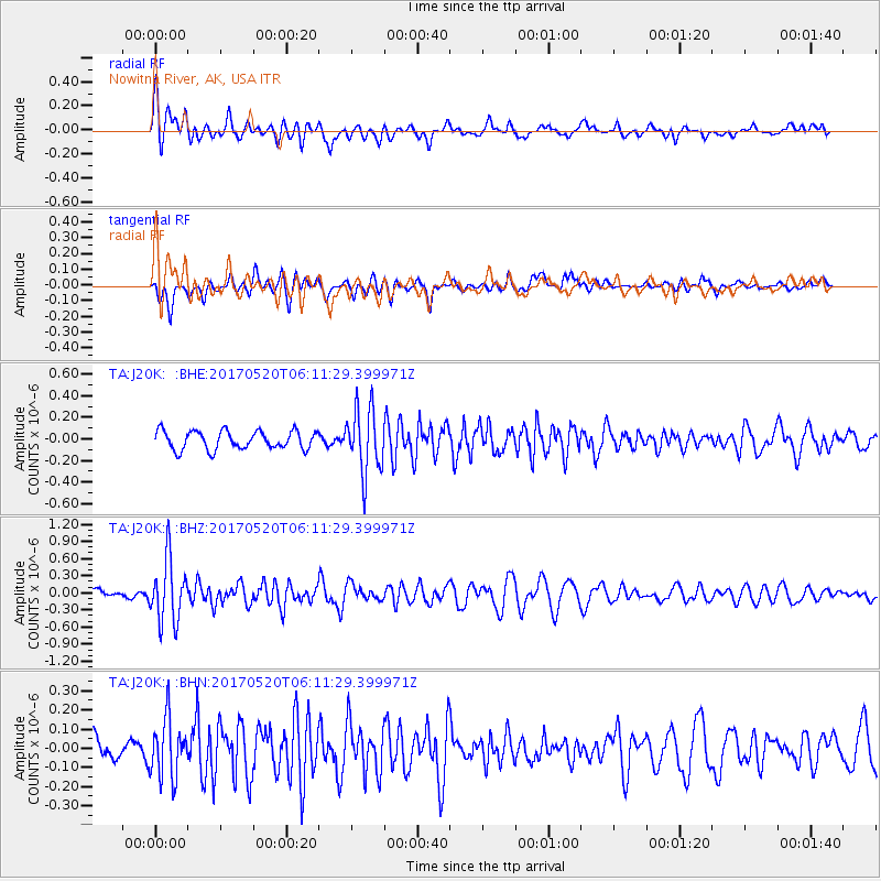
J20K Nowitna River, AK, USA - Earthquake Result Viewer
*The percent match for this event was below the threshold and hence no stack was calculated.
| Earthquake location: |
Off Coast Of Jalisco, Mexico |
| Earthquake latitude/longitude: |
17.4/-105.4 |
| Earthquake time(UTC): |
2017/05/20 (140) 06:02:13 GMT |
| Earthquake Depth: |
10 km |
| Earthquake Magnitude: |
5.8 Mww |
| Earthquake Catalog/Contributor: |
NEIC PDE/us |
|
| Network: |
TA USArray Transportable Network (new EarthScope stations) |
| Station: |
J20K Nowitna River, AK, USA |
| Lat/Lon: |
64.18 N/154.15 W |
| Elevation: |
314 m |
|
| Distance: |
57.1 deg |
| Az: |
336.899 deg |
| Baz: |
121.214 deg |
| Ray Param: |
$rayparam |
*The percent match for this event was below the threshold and hence was not used in the summary stack. |
|
| Radial Match: |
78.98678 % |
| Radial Bump: |
400 |
| Transverse Match: |
74.39063 % |
| Transverse Bump: |
393 |
| SOD ConfigId: |
13570011 |
| Insert Time: |
2019-04-28 01:36:56.202 +0000 |
| GWidth: |
2.5 |
| Max Bumps: |
400 |
| Tol: |
0.001 |
|
Signal To Noise
| Channel | StoN | STA | LTA |
| TA:J20K: :BHZ:20170520T06:11:29.399971Z | 4.9151 | 5.4141793E-7 | 1.10154005E-7 |
| TA:J20K: :BHN:20170520T06:11:29.399971Z | 2.7965982 | 1.5119319E-7 | 5.4063253E-8 |
| TA:J20K: :BHE:20170520T06:11:29.399971Z | 3.508958 | 2.967453E-7 | 8.456792E-8 |
| Arrivals |
| Ps | |
| PpPs | |
| PsPs/PpSs | |


