You are here: Home > Network List > TA - USArray Transportable Network (new EarthScope stations) Stations List
> Station M16K Timber Creek, AK, USA > Earthquake Result Viewer
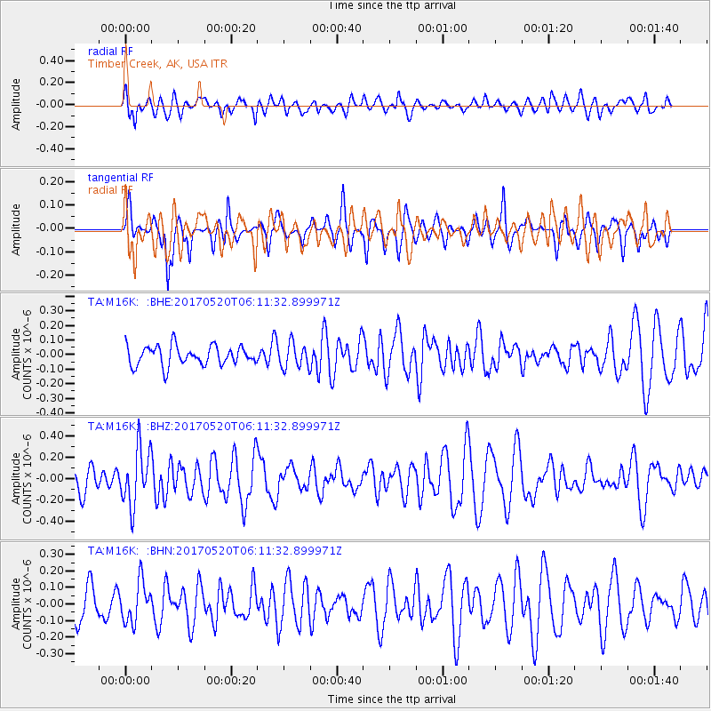
M16K Timber Creek, AK, USA - Earthquake Result Viewer
*The percent match for this event was below the threshold and hence no stack was calculated.
| Earthquake location: |
Off Coast Of Jalisco, Mexico |
| Earthquake latitude/longitude: |
17.4/-105.4 |
| Earthquake time(UTC): |
2017/05/20 (140) 06:02:13 GMT |
| Earthquake Depth: |
10 km |
| Earthquake Magnitude: |
5.8 Mww |
| Earthquake Catalog/Contributor: |
NEIC PDE/us |
|
| Network: |
TA USArray Transportable Network (new EarthScope stations) |
| Station: |
M16K Timber Creek, AK, USA |
| Lat/Lon: |
61.02 N/158.96 W |
| Elevation: |
394 m |
|
| Distance: |
57.6 deg |
| Az: |
332.341 deg |
| Baz: |
114.485 deg |
| Ray Param: |
$rayparam |
*The percent match for this event was below the threshold and hence was not used in the summary stack. |
|
| Radial Match: |
64.02703 % |
| Radial Bump: |
400 |
| Transverse Match: |
55.525116 % |
| Transverse Bump: |
342 |
| SOD ConfigId: |
13570011 |
| Insert Time: |
2019-04-28 01:37:06.543 +0000 |
| GWidth: |
2.5 |
| Max Bumps: |
400 |
| Tol: |
0.001 |
|
Signal To Noise
| Channel | StoN | STA | LTA |
| TA:M16K: :BHZ:20170520T06:11:32.899971Z | 2.0306234 | 2.717061E-7 | 1.3380429E-7 |
| TA:M16K: :BHN:20170520T06:11:32.899971Z | 1.0844375 | 1.2295213E-7 | 1.1337872E-7 |
| TA:M16K: :BHE:20170520T06:11:32.899971Z | 1.2498986 | 8.310181E-8 | 6.648684E-8 |
| Arrivals |
| Ps | |
| PpPs | |
| PsPs/PpSs | |


