You are here: Home > Network List > TA - USArray Transportable Network (new EarthScope stations) Stations List
> Station MDND Maddock, ND, USA > Earthquake Result Viewer
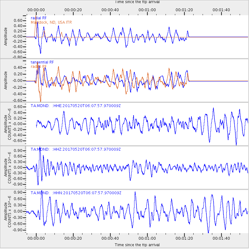
MDND Maddock, ND, USA - Earthquake Result Viewer
*The percent match for this event was below the threshold and hence no stack was calculated.
| Earthquake location: |
Off Coast Of Jalisco, Mexico |
| Earthquake latitude/longitude: |
17.4/-105.4 |
| Earthquake time(UTC): |
2017/05/20 (140) 06:02:13 GMT |
| Earthquake Depth: |
10 km |
| Earthquake Magnitude: |
5.8 Mww |
| Earthquake Catalog/Contributor: |
NEIC PDE/us |
|
| Network: |
TA USArray Transportable Network (new EarthScope stations) |
| Station: |
MDND Maddock, ND, USA |
| Lat/Lon: |
47.85 N/99.60 W |
| Elevation: |
479 m |
|
| Distance: |
30.7 deg |
| Az: |
7.611 deg |
| Baz: |
190.82 deg |
| Ray Param: |
$rayparam |
*The percent match for this event was below the threshold and hence was not used in the summary stack. |
|
| Radial Match: |
59.88189 % |
| Radial Bump: |
306 |
| Transverse Match: |
57.40056 % |
| Transverse Bump: |
400 |
| SOD ConfigId: |
13570011 |
| Insert Time: |
2019-04-28 01:37:16.414 +0000 |
| GWidth: |
2.5 |
| Max Bumps: |
400 |
| Tol: |
0.001 |
|
Signal To Noise
| Channel | StoN | STA | LTA |
| TA:MDND: :HHZ:20170520T06:07:57.970009Z | 7.7040687 | 5.136304E-7 | 6.6670026E-8 |
| TA:MDND: :HHN:20170520T06:07:57.970009Z | 3.0587053 | 4.481345E-7 | 1.4651117E-7 |
| TA:MDND: :HHE:20170520T06:07:57.970009Z | 1.0409958 | 1.6982338E-7 | 1.6313551E-7 |
| Arrivals |
| Ps | |
| PpPs | |
| PsPs/PpSs | |


