You are here: Home > Network List > TA - USArray Transportable Network (new EarthScope stations) Stations List
> Station T22A Edith, CO, USA > Earthquake Result Viewer
T22A Edith, CO, USA - Earthquake Result Viewer
| Earthquake location: |
Vanuatu Islands |
| Earthquake latitude/longitude: |
-13.5/167.0 |
| Earthquake time(UTC): |
2008/09/08 (252) 18:52:06 GMT |
| Earthquake Depth: |
110 km |
| Earthquake Magnitude: |
6.4 MB, 6.9 MW, 6.9 MW |
| Earthquake Catalog/Contributor: |
WHDF/NEIC |
|
| Network: |
TA USArray Transportable Network (new EarthScope stations) |
| Station: |
T22A Edith, CO, USA |
| Lat/Lon: |
37.01 N/106.90 W |
| Elevation: |
2224 m |
|
| Distance: |
95.0 deg |
| Az: |
53.284 deg |
| Baz: |
256.945 deg |
| Ray Param: |
0.040828925 |
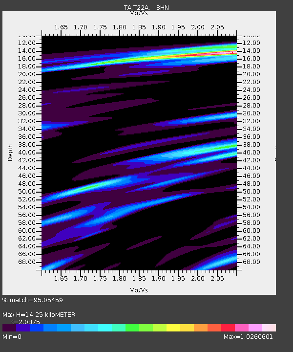
| Estimated Moho Depth: |
14.25 km |
| Estimated Crust Vp/Vs: |
2.09 |
| Assumed Crust Vp: |
6.159 km/s |
| Estimated Crust Vs: |
2.95 km/s |
| Estimated Crust Poisson's Ratio: |
0.35 |
|
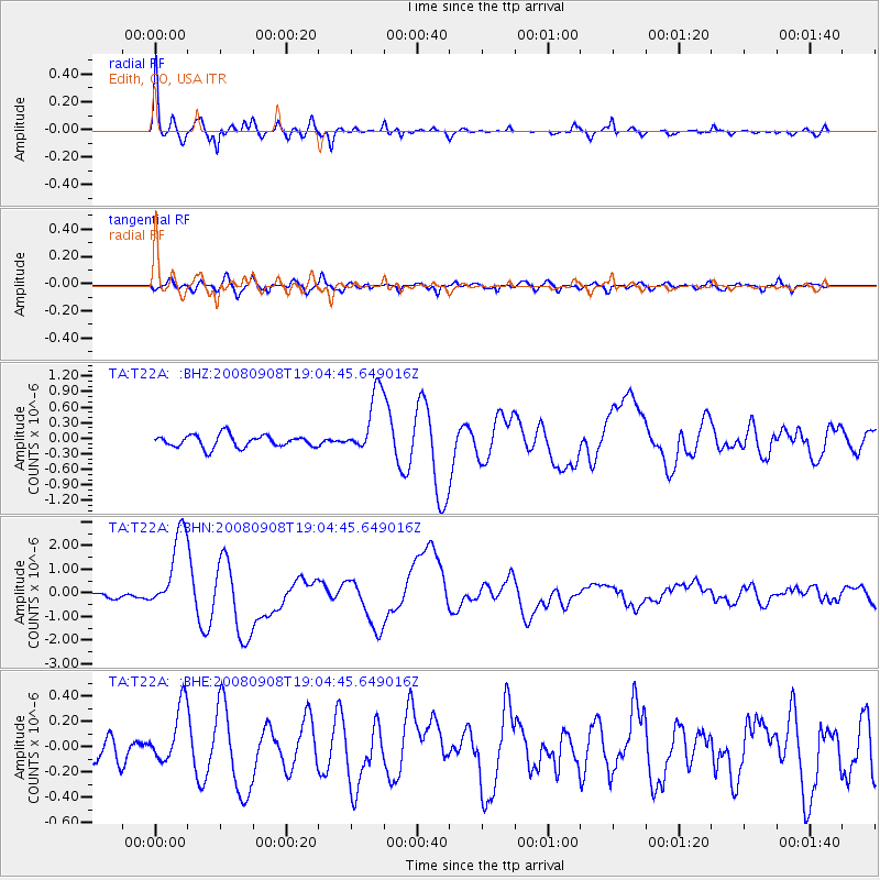
| Radial Match: |
95.05459 % |
| Radial Bump: |
400 |
| Transverse Match: |
78.09053 % |
| Transverse Bump: |
400 |
| SOD ConfigId: |
2560 |
| Insert Time: |
2010-03-05 23:59:11.571 +0000 |
| GWidth: |
2.5 |
| Max Bumps: |
400 |
| Tol: |
0.001 |
|
Signal To Noise
| Channel | StoN | STA | LTA |
| TA:T22A: :BHN:20080908T19:04:45.649016Z | 19.210865 | 1.7122456E-6 | 8.9129024E-8 |
| TA:T22A: :BHE:20080908T19:04:45.649016Z | 2.0460732 | 2.3506738E-7 | 1.1488707E-7 |
| TA:T22A: :BHZ:20080908T19:04:45.649016Z | 5.2759643 | 6.210186E-7 | 1.1770714E-7 |
| Arrivals |
| Ps | 2.6 SECOND |
| PpPs | 7.0 SECOND |
| PsPs/PpSs | 9.6 SECOND |


