You are here: Home > Network List > AK - Alaska Regional Network Stations List
> Station CUT Chulitna, AK, USA > Earthquake Result Viewer
CUT Chulitna, AK, USA - Earthquake Result Viewer
| Earthquake location: |
Chiapas, Mexico |
| Earthquake latitude/longitude: |
17.1/-94.0 |
| Earthquake time(UTC): |
2017/05/20 (140) 17:58:46 GMT |
| Earthquake Depth: |
144 km |
| Earthquake Magnitude: |
5.7 Mww |
| Earthquake Catalog/Contributor: |
NEIC PDE/us |
|
| Network: |
AK Alaska Regional Network |
| Station: |
CUT Chulitna, AK, USA |
| Lat/Lon: |
62.41 N/150.26 W |
| Elevation: |
574 m |
|
| Distance: |
59.6 deg |
| Az: |
333.318 deg |
| Baz: |
112.763 deg |
| Ray Param: |
0.061649803 |
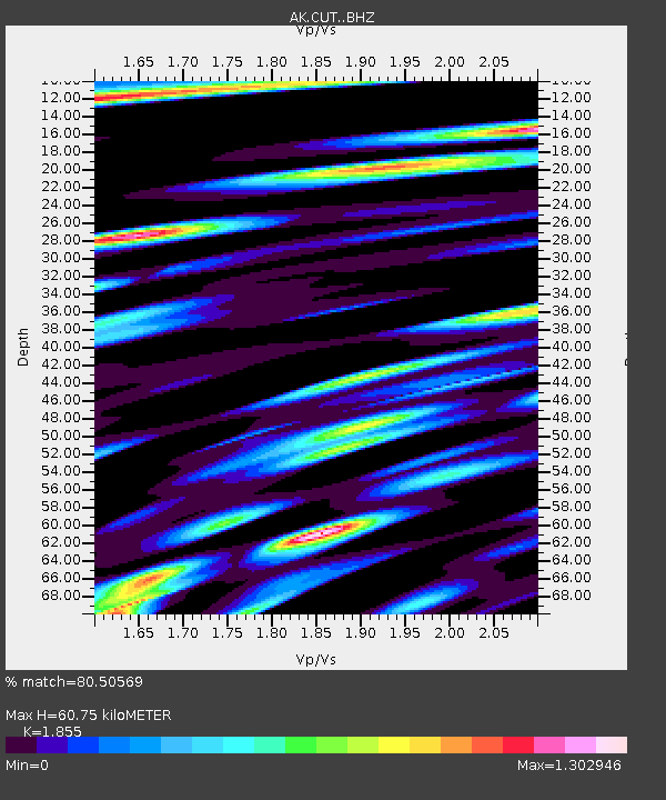
| Estimated Moho Depth: |
60.75 km |
| Estimated Crust Vp/Vs: |
1.86 |
| Assumed Crust Vp: |
6.438 km/s |
| Estimated Crust Vs: |
3.471 km/s |
| Estimated Crust Poisson's Ratio: |
0.30 |
|
| Radial Match: |
80.50569 % |
| Radial Bump: |
400 |
| Transverse Match: |
74.59806 % |
| Transverse Bump: |
400 |
| SOD ConfigId: |
13570011 |
| Insert Time: |
2019-04-28 01:39:18.267 +0000 |
| GWidth: |
2.5 |
| Max Bumps: |
400 |
| Tol: |
0.001 |
|

Signal To Noise
| Channel | StoN | STA | LTA |
| AK:CUT: :BHZ:20170520T18:08:04.380007Z | 4.933798 | 5.2579855E-7 | 1.0657076E-7 |
| AK:CUT: :BHN:20170520T18:08:04.380007Z | 1.6625928 | 2.8370374E-7 | 1.7063934E-7 |
| AK:CUT: :BHE:20170520T18:08:04.380007Z | 1.121057 | 3.028675E-7 | 2.7016245E-7 |
| Arrivals |
| Ps | 8.4 SECOND |
| PpPs | 26 SECOND |
| PsPs/PpSs | 34 SECOND |


