You are here: Home > Network List > TA - USArray Transportable Network (new EarthScope stations) Stations List
> Station T22A Edith, CO, USA > Earthquake Result Viewer
T22A Edith, CO, USA - Earthquake Result Viewer
| Earthquake location: |
Kuril Islands |
| Earthquake latitude/longitude: |
48.3/154.2 |
| Earthquake time(UTC): |
2009/09/10 (253) 02:46:50 GMT |
| Earthquake Depth: |
36 km |
| Earthquake Magnitude: |
6.0 MB, 5.5 MS, 6.0 MW, 5.8 MW |
| Earthquake Catalog/Contributor: |
WHDF/NEIC |
|
| Network: |
TA USArray Transportable Network (new EarthScope stations) |
| Station: |
T22A Edith, CO, USA |
| Lat/Lon: |
37.01 N/106.90 W |
| Elevation: |
2224 m |
|
| Distance: |
68.7 deg |
| Az: |
58.092 deg |
| Baz: |
314.934 deg |
| Ray Param: |
0.056089688 |
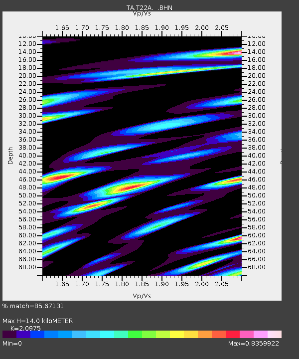
| Estimated Moho Depth: |
14.0 km |
| Estimated Crust Vp/Vs: |
2.10 |
| Assumed Crust Vp: |
6.159 km/s |
| Estimated Crust Vs: |
2.936 km/s |
| Estimated Crust Poisson's Ratio: |
0.35 |
|
| Radial Match: |
85.67131 % |
| Radial Bump: |
400 |
| Transverse Match: |
82.18458 % |
| Transverse Bump: |
400 |
| SOD ConfigId: |
2622 |
| Insert Time: |
2010-03-05 23:59:43.546 +0000 |
| GWidth: |
2.5 |
| Max Bumps: |
400 |
| Tol: |
0.001 |
|
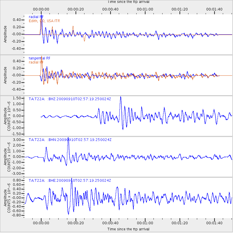
Signal To Noise
| Channel | StoN | STA | LTA |
| TA:T22A: :BHN:20090910T02:57:19.250024Z | 8.806252 | 6.354566E-7 | 7.2159715E-8 |
| TA:T22A: :BHE:20090910T02:57:19.250024Z | 1.7622483 | 2.1652474E-7 | 1.2286847E-7 |
| TA:T22A: :BHZ:20090910T02:57:19.250024Z | 5.3745975 | 2.9726843E-7 | 5.5309897E-8 |
| Arrivals |
| Ps | 2.6 SECOND |
| PpPs | 6.8 SECOND |
| PsPs/PpSs | 9.4 SECOND |


