You are here: Home > Network List > TA - USArray Transportable Network (new EarthScope stations) Stations List
> Station T22A Edith, CO, USA > Earthquake Result Viewer
T22A Edith, CO, USA - Earthquake Result Viewer

| Earthquake location: |
Santa Cruz Islands |
| Earthquake latitude/longitude: |
-12.4/166.1 |
| Earthquake time(UTC): |
2009/10/07 (280) 22:50:15 GMT |
| Earthquake Depth: |
21 km |
| Earthquake Magnitude: |
5.8 MB |
| Earthquake Catalog/Contributor: |
WHDF/NEIC |
|
| Network: |
TA USArray Transportable Network (new EarthScope stations) |
| Station: |
T22A Edith, CO, USA |
| Lat/Lon: |
37.01 N/106.90 W |
| Elevation: |
2224 m |
|
| Distance: |
95.0 deg |
| Az: |
53.358 deg |
| Baz: |
258.349 deg |
| Ray Param: |
0.040894262 |
| Estimated Moho Depth: |
10.25 km |
| Estimated Crust Vp/Vs: |
1.61 |
| Assumed Crust Vp: |
6.159 km/s |
| Estimated Crust Vs: |
3.837 km/s |
| Estimated Crust Poisson's Ratio: |
0.18 |
|
| Radial Match: |
95.92569 % |
| Radial Bump: |
400 |
| Transverse Match: |
46.962845 % |
| Transverse Bump: |
230 |
| SOD ConfigId: |
2622 |
| Insert Time: |
2010-03-05 23:59:49.673 +0000 |
| GWidth: |
2.5 |
| Max Bumps: |
400 |
| Tol: |
0.001 |
|
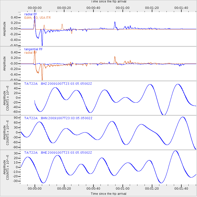
Signal To Noise
| Channel | StoN | STA | LTA |
| TA:T22A: :BHN:20091007T23:03:05.05002Z | 1.9165727 | 6.554E-5 | 3.419646E-5 |
| TA:T22A: :BHE:20091007T23:03:05.05002Z | 1.9905927 | 1.7193193E-5 | 8.637223E-6 |
| TA:T22A: :BHZ:20091007T23:03:05.05002Z | 0.70981914 | 2.3256194E-5 | 3.276355E-5 |
| Arrivals |
| Ps | 1.0 SECOND |
| PpPs | 4.2 SECOND |
| PsPs/PpSs | 5.3 SECOND |


