T22A Edith, CO, USA - Earthquake Result Viewer
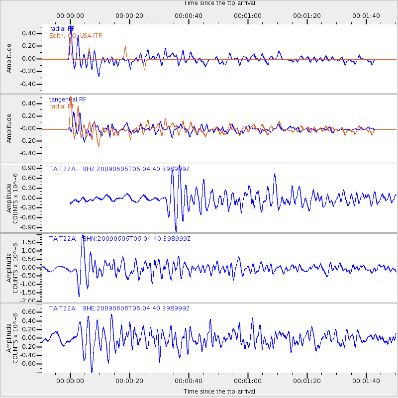
Earthquake location: Near East Coast Of Honshu, Japan
Earthquake latitude/longitude: 35.5/140.9
Earthquake time(UTC): 2009/06/06 (157) 05:52:43 GMT
Earthquake Depth: 34 km
Earthquake Magnitude: 5.8 MB, 5.4 MS, 5.8 MW, 5.7 MW
Earthquake Catalog/Contributor: WHDF/NEIC
Network: TA USArray Transportable Network (new EarthScope stations)
Station: T22A Edith, CO, USA
Lat/Lon: 37.01 N/106.90 W
Elevation: 2224 m
Distance: 84.3 deg
Az: 48.15 deg
Baz: 310.579 deg
Ray Param: 0.045554128
Estimated Moho Depth: 17.75 km
Estimated Crust Vp/Vs: 1.89
Assumed Crust Vp: 6.159 km/s
Estimated Crust Vs: 3.263 km/s
Estimated Crust Poisson's Ratio: 0.30
Radial Match: 89.80458 %
Radial Bump: 400
Transverse Match: 79.622574 %
Transverse Bump: 400
SOD ConfigId: 2648
Insert Time: 2010-03-05 23:59:59.480 +0000
GWidth: 2.5
Max Bumps: 400
Tol: 0.001

Signal To Noise

ChannelStoNSTALTA
TA:T22A: :BHN:20090606T06:04:40.398999Z10.8385079.078614E-78.376259E-8
TA:T22A: :BHE:20090606T06:04:40.398999Z2.41272642.0793283E-78.6181686E-8
TA:T22A: :BHZ:20090606T06:04:40.398999Z4.96764763.356173E-76.7560606E-8
Arrivals
Ps2.6 SECOND
PpPs8.1 SECOND
PsPs/PpSs11 SECOND