You are here: Home > Network List > NE - New England Seismic Network Stations List
> Station HNH Hanover, NH, USA > Earthquake Result Viewer
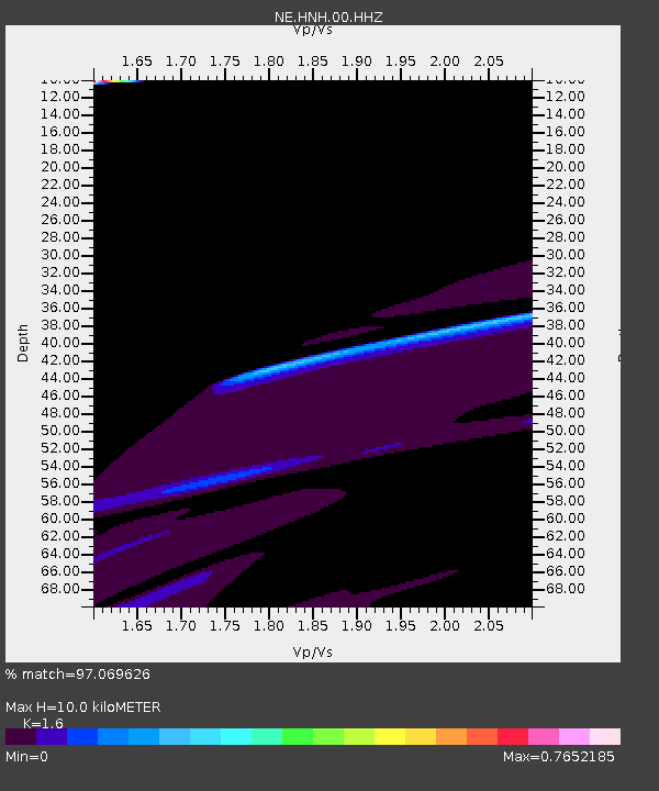
HNH Hanover, NH, USA - Earthquake Result Viewer
| Earthquake location: |
Kyrgyzstan |
| Earthquake latitude/longitude: |
41.7/74.7 |
| Earthquake time(UTC): |
2015/12/07 (341) 08:30:57 GMT |
| Earthquake Depth: |
26 km |
| Earthquake Magnitude: |
5.5 MB |
| Earthquake Catalog/Contributor: |
NEIC PDE/NEIC COMCAT |
|
| Network: |
NE New England Seismic Network |
| Station: |
HNH Hanover, NH, USA |
| Lat/Lon: |
43.71 N/72.29 W |
| Elevation: |
180 m |
|
| Distance: |
90.0 deg |
| Az: |
336.696 deg |
| Baz: |
24.119 deg |
| Ray Param: |
0.04170537 |
| Estimated Moho Depth: |
10.0 km |
| Estimated Crust Vp/Vs: |
1.60 |
| Assumed Crust Vp: |
6.419 km/s |
| Estimated Crust Vs: |
4.012 km/s |
| Estimated Crust Poisson's Ratio: |
0.18 |
|
| Radial Match: |
97.069626 % |
| Radial Bump: |
346 |
| Transverse Match: |
64.719 % |
| Transverse Bump: |
400 |
| SOD ConfigId: |
1259291 |
| Insert Time: |
2015-12-21 09:01:59.388 +0000 |
| GWidth: |
2.5 |
| Max Bumps: |
400 |
| Tol: |
0.001 |
|

Signal To Noise
| Channel | StoN | STA | LTA |
| NE:HNH:00:HHZ:20151207T08:43:22.604021Z | 1.9045001 | 7.834539E-5 | 4.113698E-5 |
| NE:HNH:00:HH1:20151207T08:43:22.604021Z | 1.9666388 | 4.2909418E-5 | 2.1818658E-5 |
| NE:HNH:00:HH2:20151207T08:43:22.604021Z | 0.7718708 | 1.2816265E-5 | 1.660416E-5 |
| Arrivals |
| Ps | 1.0 SECOND |
| PpPs | 4.0 SECOND |
| PsPs/PpSs | 4.9 SECOND |


