You are here: Home > Network List > TA - USArray Transportable Network (new EarthScope stations) Stations List
> Station T22A Edith, CO, USA > Earthquake Result Viewer
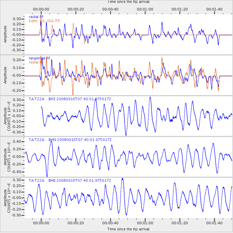
T22A Edith, CO, USA - Earthquake Result Viewer
*The percent match for this event was below the threshold and hence no stack was calculated.
| Earthquake location: |
Central Mid-Atlantic Ridge |
| Earthquake latitude/longitude: |
0.9/-29.0 |
| Earthquake time(UTC): |
2008/09/16 (260) 07:28:25 GMT |
| Earthquake Depth: |
10 km |
| Earthquake Magnitude: |
5.8 MW, 5.2 MS, 5.2 MB, 5.8 MW |
| Earthquake Catalog/Contributor: |
WHDF/NEIC |
|
| Network: |
TA USArray Transportable Network (new EarthScope stations) |
| Station: |
T22A Edith, CO, USA |
| Lat/Lon: |
37.01 N/106.90 W |
| Elevation: |
2224 m |
|
| Distance: |
79.8 deg |
| Az: |
307.323 deg |
| Baz: |
96.597 deg |
| Ray Param: |
$rayparam |
*The percent match for this event was below the threshold and hence was not used in the summary stack. |
|
| Radial Match: |
54.878777 % |
| Radial Bump: |
400 |
| Transverse Match: |
56.57555 % |
| Transverse Bump: |
383 |
| SOD ConfigId: |
2560 |
| Insert Time: |
2010-03-06 00:00:12.246 +0000 |
| GWidth: |
2.5 |
| Max Bumps: |
400 |
| Tol: |
0.001 |
|
Signal To Noise
| Channel | StoN | STA | LTA |
| TA:T22A: :BHN:20080916T07:40:01.975017Z | 2.9872944 | 1.9931608E-7 | 6.672127E-8 |
| TA:T22A: :BHE:20080916T07:40:01.975017Z | 1.7245333 | 1.4942668E-7 | 8.66476E-8 |
| TA:T22A: :BHZ:20080916T07:40:01.975017Z | 2.9535167 | 1.912695E-7 | 6.4759924E-8 |
| Arrivals |
| Ps | |
| PpPs | |
| PsPs/PpSs | |


