You are here: Home > Network List > TA - USArray Transportable Network (new EarthScope stations) Stations List
> Station T22A Edith, CO, USA > Earthquake Result Viewer
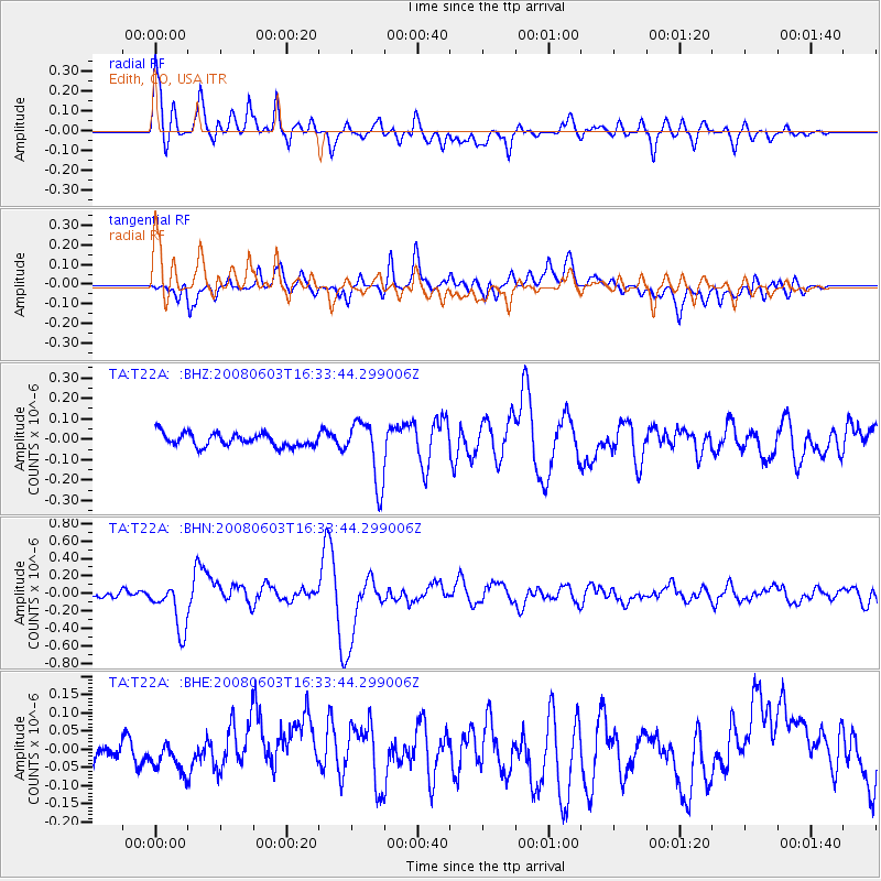
T22A Edith, CO, USA - Earthquake Result Viewer
*The percent match for this event was below the threshold and hence no stack was calculated.
| Earthquake location: |
Solomon Islands |
| Earthquake latitude/longitude: |
-10.5/161.3 |
| Earthquake time(UTC): |
2008/06/03 (155) 16:20:50 GMT |
| Earthquake Depth: |
84 km |
| Earthquake Magnitude: |
6.2 MB, 6.2 MW, 6.2 MW |
| Earthquake Catalog/Contributor: |
WHDF/NEIC |
|
| Network: |
TA USArray Transportable Network (new EarthScope stations) |
| Station: |
T22A Edith, CO, USA |
| Lat/Lon: |
37.01 N/106.90 W |
| Elevation: |
2224 m |
|
| Distance: |
97.7 deg |
| Az: |
53.83 deg |
| Baz: |
262.679 deg |
| Ray Param: |
$rayparam |
*The percent match for this event was below the threshold and hence was not used in the summary stack. |
|
| Radial Match: |
79.29498 % |
| Radial Bump: |
400 |
| Transverse Match: |
74.85332 % |
| Transverse Bump: |
400 |
| SOD ConfigId: |
2504 |
| Insert Time: |
2010-03-06 00:00:32.776 +0000 |
| GWidth: |
2.5 |
| Max Bumps: |
400 |
| Tol: |
0.001 |
|
Signal To Noise
| Channel | StoN | STA | LTA |
| TA:T22A: :BHN:20080603T16:33:44.299006Z | 7.349512 | 2.7493172E-7 | 3.740816E-8 |
| TA:T22A: :BHE:20080603T16:33:44.299006Z | 1.7007374 | 4.0622446E-8 | 2.3885196E-8 |
| TA:T22A: :BHZ:20080603T16:33:44.299006Z | 4.871406 | 1.5191604E-7 | 3.1185255E-8 |
| Arrivals |
| Ps | |
| PpPs | |
| PsPs/PpSs | |


