You are here: Home > Network List > TA - USArray Transportable Network (new EarthScope stations) Stations List
> Station A21K Barrow, AK, USA > Earthquake Result Viewer
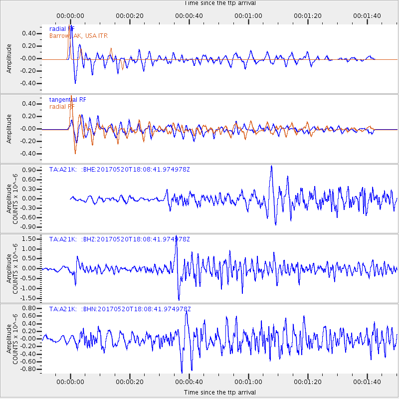
A21K Barrow, AK, USA - Earthquake Result Viewer
*The percent match for this event was below the threshold and hence no stack was calculated.
| Earthquake location: |
Chiapas, Mexico |
| Earthquake latitude/longitude: |
17.1/-94.0 |
| Earthquake time(UTC): |
2017/05/20 (140) 17:58:46 GMT |
| Earthquake Depth: |
144 km |
| Earthquake Magnitude: |
5.7 Mww |
| Earthquake Catalog/Contributor: |
NEIC PDE/us |
|
| Network: |
TA USArray Transportable Network (new EarthScope stations) |
| Station: |
A21K Barrow, AK, USA |
| Lat/Lon: |
71.32 N/156.62 W |
| Elevation: |
577 m |
|
| Distance: |
65.2 deg |
| Az: |
341.637 deg |
| Baz: |
110.768 deg |
| Ray Param: |
$rayparam |
*The percent match for this event was below the threshold and hence was not used in the summary stack. |
|
| Radial Match: |
76.16295 % |
| Radial Bump: |
400 |
| Transverse Match: |
79.05572 % |
| Transverse Bump: |
400 |
| SOD ConfigId: |
13570011 |
| Insert Time: |
2019-04-28 01:43:37.123 +0000 |
| GWidth: |
2.5 |
| Max Bumps: |
400 |
| Tol: |
0.001 |
|
Signal To Noise
| Channel | StoN | STA | LTA |
| TA:A21K: :BHZ:20170520T18:08:41.974978Z | 5.506711 | 3.110778E-7 | 5.6490666E-8 |
| TA:A21K: :BHN:20170520T18:08:41.974978Z | 1.7091053 | 1.2645214E-7 | 7.398733E-8 |
| TA:A21K: :BHE:20170520T18:08:41.974978Z | 2.396326 | 1.4810335E-7 | 6.1804336E-8 |
| Arrivals |
| Ps | |
| PpPs | |
| PsPs/PpSs | |


