You are here: Home > Network List > TA - USArray Transportable Network (new EarthScope stations) Stations List
> Station D23K Nanushuk River, AK USA > Earthquake Result Viewer
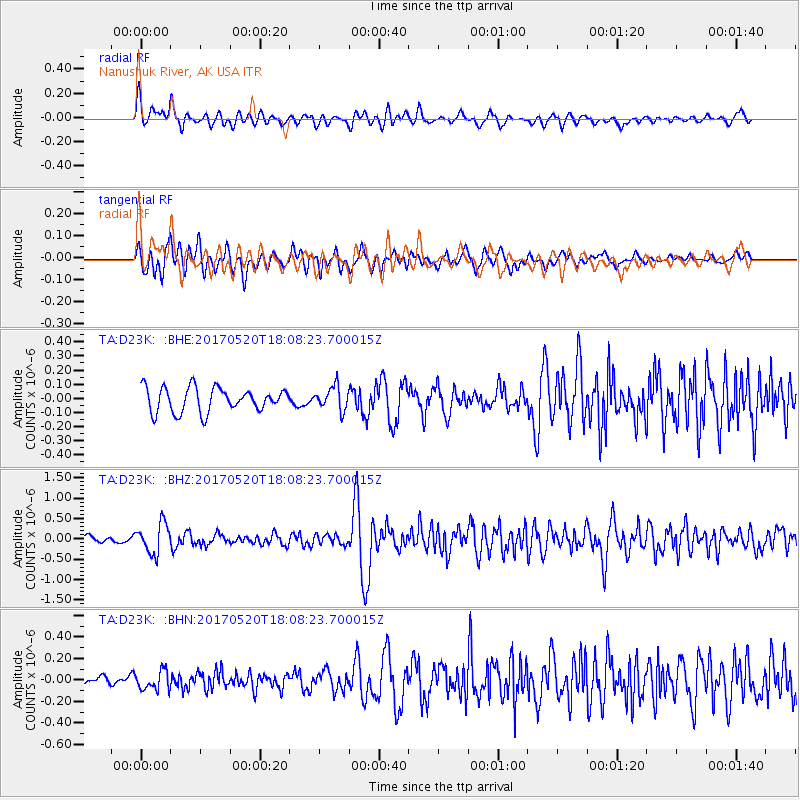
D23K Nanushuk River, AK USA - Earthquake Result Viewer
*The percent match for this event was below the threshold and hence no stack was calculated.
| Earthquake location: |
Chiapas, Mexico |
| Earthquake latitude/longitude: |
17.1/-94.0 |
| Earthquake time(UTC): |
2017/05/20 (140) 17:58:46 GMT |
| Earthquake Depth: |
144 km |
| Earthquake Magnitude: |
5.7 Mww |
| Earthquake Catalog/Contributor: |
NEIC PDE/us |
|
| Network: |
TA USArray Transportable Network (new EarthScope stations) |
| Station: |
D23K Nanushuk River, AK USA |
| Lat/Lon: |
68.97 N/150.68 W |
| Elevation: |
406 m |
|
| Distance: |
62.5 deg |
| Az: |
340.106 deg |
| Baz: |
115.674 deg |
| Ray Param: |
$rayparam |
*The percent match for this event was below the threshold and hence was not used in the summary stack. |
|
| Radial Match: |
72.8459 % |
| Radial Bump: |
400 |
| Transverse Match: |
70.92027 % |
| Transverse Bump: |
400 |
| SOD ConfigId: |
13570011 |
| Insert Time: |
2019-04-28 01:43:42.249 +0000 |
| GWidth: |
2.5 |
| Max Bumps: |
400 |
| Tol: |
0.001 |
|
Signal To Noise
| Channel | StoN | STA | LTA |
| TA:D23K: :BHZ:20170520T18:08:23.700015Z | 4.5008435 | 3.6731194E-7 | 8.160957E-8 |
| TA:D23K: :BHN:20170520T18:08:23.700015Z | 1.5289725 | 8.871535E-8 | 5.8022856E-8 |
| TA:D23K: :BHE:20170520T18:08:23.700015Z | 0.9927563 | 8.368693E-8 | 8.4297554E-8 |
| Arrivals |
| Ps | |
| PpPs | |
| PsPs/PpSs | |


