You are here: Home > Network List > TA - USArray Transportable Network (new EarthScope stations) Stations List
> Station M31M Drury Creek, Yukon, CA > Earthquake Result Viewer
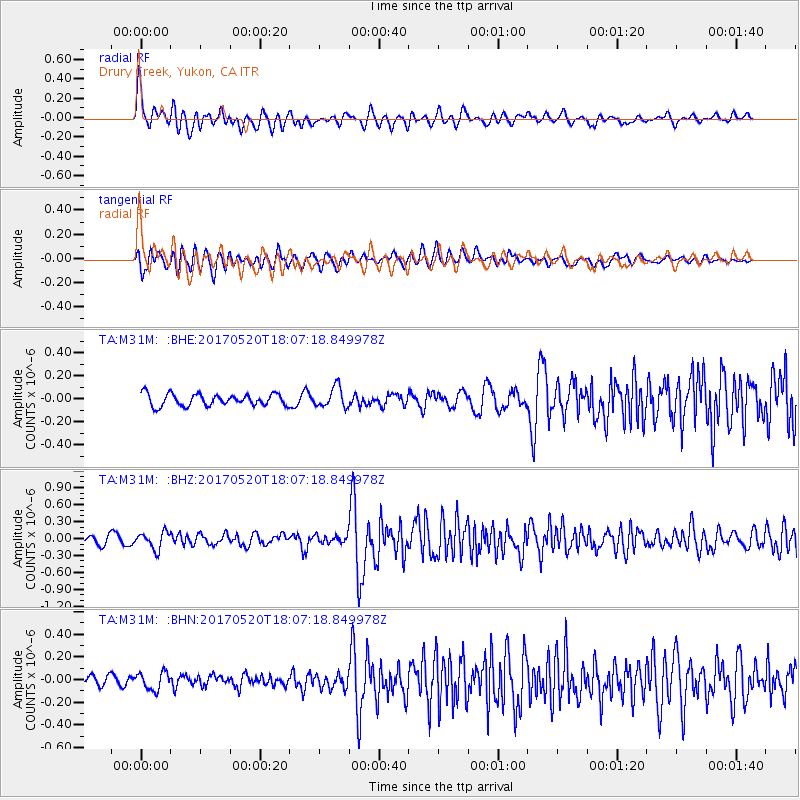
M31M Drury Creek, Yukon, CA - Earthquake Result Viewer
*The percent match for this event was below the threshold and hence no stack was calculated.
| Earthquake location: |
Chiapas, Mexico |
| Earthquake latitude/longitude: |
17.1/-94.0 |
| Earthquake time(UTC): |
2017/05/20 (140) 17:58:46 GMT |
| Earthquake Depth: |
144 km |
| Earthquake Magnitude: |
5.7 Mww |
| Earthquake Catalog/Contributor: |
NEIC PDE/us |
|
| Network: |
TA USArray Transportable Network (new EarthScope stations) |
| Station: |
M31M Drury Creek, Yukon, CA |
| Lat/Lon: |
62.20 N/134.39 W |
| Elevation: |
639 m |
|
| Distance: |
53.1 deg |
| Az: |
337.684 deg |
| Baz: |
129.238 deg |
| Ray Param: |
$rayparam |
*The percent match for this event was below the threshold and hence was not used in the summary stack. |
|
| Radial Match: |
75.90985 % |
| Radial Bump: |
400 |
| Transverse Match: |
69.07493 % |
| Transverse Bump: |
400 |
| SOD ConfigId: |
13570011 |
| Insert Time: |
2019-04-28 01:44:17.919 +0000 |
| GWidth: |
2.5 |
| Max Bumps: |
400 |
| Tol: |
0.001 |
|
Signal To Noise
| Channel | StoN | STA | LTA |
| TA:M31M: :BHZ:20170520T18:07:18.849978Z | 2.0598445 | 1.513491E-7 | 7.347598E-8 |
| TA:M31M: :BHN:20170520T18:07:18.849978Z | 1.6634105 | 7.7755836E-8 | 4.6744827E-8 |
| TA:M31M: :BHE:20170520T18:07:18.849978Z | 1.7187061 | 8.867574E-8 | 5.1594476E-8 |
| Arrivals |
| Ps | |
| PpPs | |
| PsPs/PpSs | |


