You are here: Home > Network List > TA - USArray Transportable Network (new EarthScope stations) Stations List
> Station P17K Kvichak River, AK, USA > Earthquake Result Viewer
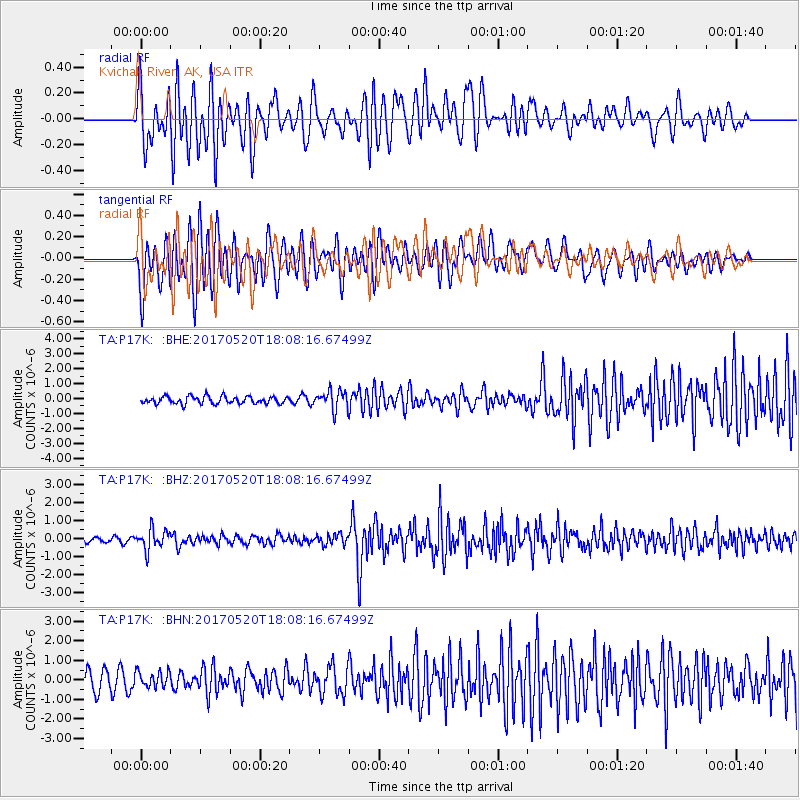
P17K Kvichak River, AK, USA - Earthquake Result Viewer
*The percent match for this event was below the threshold and hence no stack was calculated.
| Earthquake location: |
Chiapas, Mexico |
| Earthquake latitude/longitude: |
17.1/-94.0 |
| Earthquake time(UTC): |
2017/05/20 (140) 17:58:46 GMT |
| Earthquake Depth: |
144 km |
| Earthquake Magnitude: |
5.7 Mww |
| Earthquake Catalog/Contributor: |
NEIC PDE/us |
|
| Network: |
TA USArray Transportable Network (new EarthScope stations) |
| Station: |
P17K Kvichak River, AK, USA |
| Lat/Lon: |
59.20 N/156.44 W |
| Elevation: |
91 m |
|
| Distance: |
61.4 deg |
| Az: |
328.692 deg |
| Baz: |
105.097 deg |
| Ray Param: |
$rayparam |
*The percent match for this event was below the threshold and hence was not used in the summary stack. |
|
| Radial Match: |
74.54796 % |
| Radial Bump: |
400 |
| Transverse Match: |
68.03101 % |
| Transverse Bump: |
400 |
| SOD ConfigId: |
13570011 |
| Insert Time: |
2019-04-28 01:44:28.904 +0000 |
| GWidth: |
2.5 |
| Max Bumps: |
400 |
| Tol: |
0.001 |
|
Signal To Noise
| Channel | StoN | STA | LTA |
| TA:P17K: :BHZ:20170520T18:08:16.67499Z | 2.2971382 | 5.673323E-7 | 2.469735E-7 |
| TA:P17K: :BHN:20170520T18:08:16.67499Z | 0.7573887 | 4.0492927E-7 | 5.346386E-7 |
| TA:P17K: :BHE:20170520T18:08:16.67499Z | 2.7888503 | 6.802595E-7 | 2.4392114E-7 |
| Arrivals |
| Ps | |
| PpPs | |
| PsPs/PpSs | |


