You are here: Home > Network List > TA - USArray Transportable Network (new EarthScope stations) Stations List
> Station P33M Teslin, Yukon, CA > Earthquake Result Viewer
P33M Teslin, Yukon, CA - Earthquake Result Viewer
| Earthquake location: |
Chiapas, Mexico |
| Earthquake latitude/longitude: |
17.1/-94.0 |
| Earthquake time(UTC): |
2017/05/20 (140) 17:58:46 GMT |
| Earthquake Depth: |
144 km |
| Earthquake Magnitude: |
5.7 Mww |
| Earthquake Catalog/Contributor: |
NEIC PDE/us |
|
| Network: |
TA USArray Transportable Network (new EarthScope stations) |
| Station: |
P33M Teslin, Yukon, CA |
| Lat/Lon: |
60.21 N/132.82 W |
| Elevation: |
1066 m |
|
| Distance: |
51.3 deg |
| Az: |
336.347 deg |
| Baz: |
129.796 deg |
| Ray Param: |
0.0670205 |
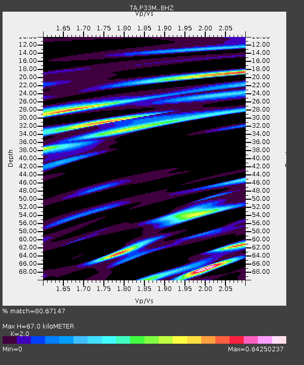
| Estimated Moho Depth: |
67.0 km |
| Estimated Crust Vp/Vs: |
2.00 |
| Assumed Crust Vp: |
6.419 km/s |
| Estimated Crust Vs: |
3.21 km/s |
| Estimated Crust Poisson's Ratio: |
0.33 |
|
| Radial Match: |
80.67147 % |
| Radial Bump: |
388 |
| Transverse Match: |
75.13056 % |
| Transverse Bump: |
400 |
| SOD ConfigId: |
13570011 |
| Insert Time: |
2019-04-28 01:44:30.295 +0000 |
| GWidth: |
2.5 |
| Max Bumps: |
400 |
| Tol: |
0.001 |
|

Signal To Noise
| Channel | StoN | STA | LTA |
| TA:P33M: :BHZ:20170520T18:07:05.149996Z | 2.8410914 | 2.0072812E-7 | 7.0651765E-8 |
| TA:P33M: :BHN:20170520T18:07:05.149996Z | 1.5357242 | 7.531131E-8 | 4.903961E-8 |
| TA:P33M: :BHE:20170520T18:07:05.149996Z | 0.93427795 | 7.102545E-8 | 7.602175E-8 |
| Arrivals |
| Ps | 11 SECOND |
| PpPs | 30 SECOND |
| PsPs/PpSs | 41 SECOND |


