You are here: Home > Network List > IW - Intermountain West Stations List
> Station PLID Pearl Lake, Idaho, USA > Earthquake Result Viewer
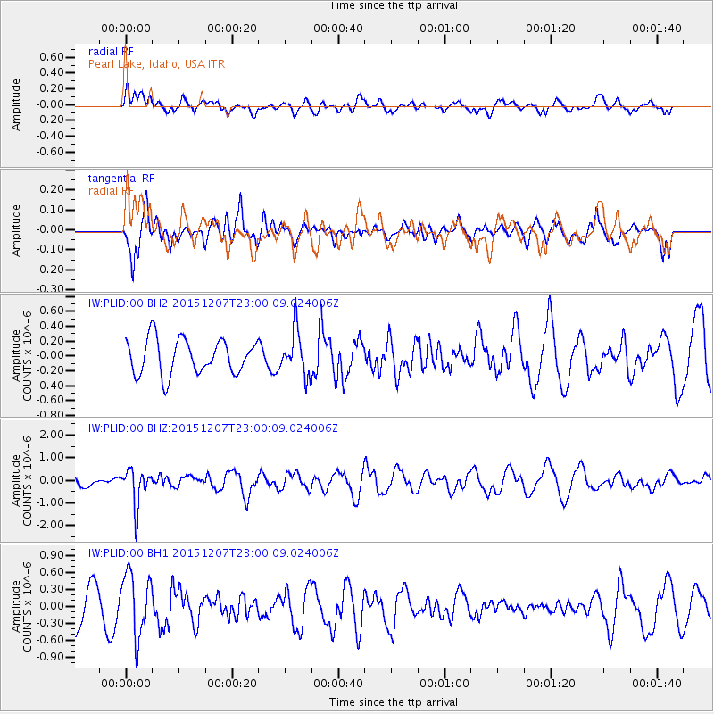
PLID Pearl Lake, Idaho, USA - Earthquake Result Viewer
*The percent match for this event was below the threshold and hence no stack was calculated.
| Earthquake location: |
Guatemala |
| Earthquake latitude/longitude: |
14.2/-90.9 |
| Earthquake time(UTC): |
2015/12/07 (341) 22:53:36 GMT |
| Earthquake Depth: |
109 km |
| Earthquake Magnitude: |
5.7 MB |
| Earthquake Catalog/Contributor: |
NEIC PDE/NEIC COMCAT |
|
| Network: |
IW Intermountain West |
| Station: |
PLID Pearl Lake, Idaho, USA |
| Lat/Lon: |
45.09 N/116.00 W |
| Elevation: |
2164 m |
|
| Distance: |
37.4 deg |
| Az: |
330.311 deg |
| Baz: |
137.31 deg |
| Ray Param: |
$rayparam |
*The percent match for this event was below the threshold and hence was not used in the summary stack. |
|
| Radial Match: |
50.1815 % |
| Radial Bump: |
400 |
| Transverse Match: |
59.09836 % |
| Transverse Bump: |
387 |
| SOD ConfigId: |
1259291 |
| Insert Time: |
2015-12-21 23:06:06.694 +0000 |
| GWidth: |
2.5 |
| Max Bumps: |
400 |
| Tol: |
0.001 |
|
Signal To Noise
| Channel | StoN | STA | LTA |
| IW:PLID:00:BHZ:20151207T23:00:09.024006Z | 2.3384824 | 8.465399E-7 | 3.6200396E-7 |
| IW:PLID:00:BH1:20151207T23:00:09.024006Z | 1.2866207 | 5.6216675E-7 | 4.3693274E-7 |
| IW:PLID:00:BH2:20151207T23:00:09.024006Z | 1.3159243 | 3.0602882E-7 | 2.325581E-7 |
| Arrivals |
| Ps | |
| PpPs | |
| PsPs/PpSs | |


