You are here: Home > Network List > TA - USArray Transportable Network (new EarthScope stations) Stations List
> Station T22A Edith, CO, USA > Earthquake Result Viewer
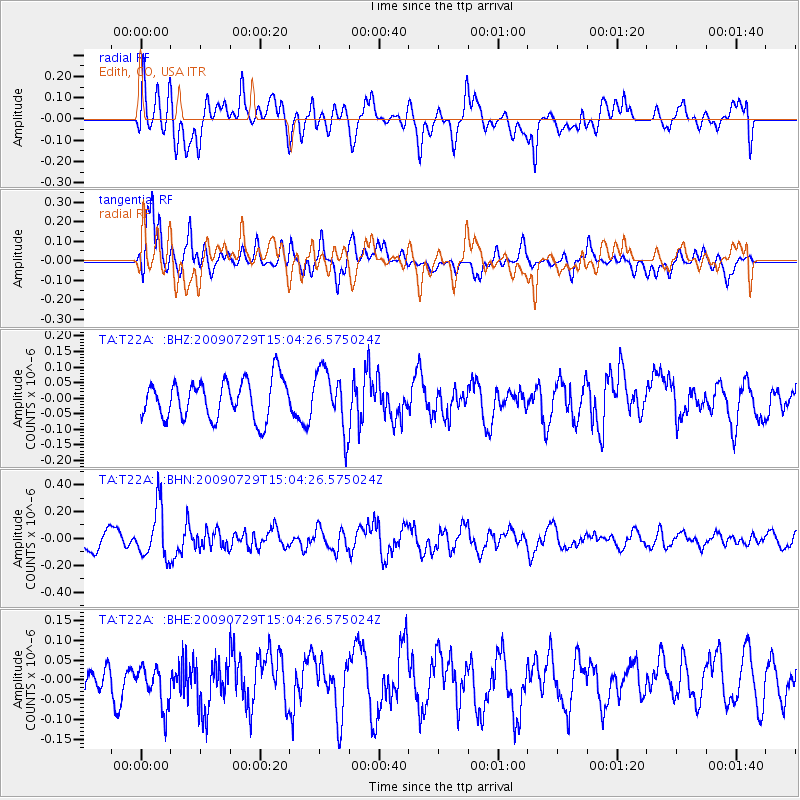
T22A Edith, CO, USA - Earthquake Result Viewer
*The percent match for this event was below the threshold and hence no stack was calculated.
| Earthquake location: |
Volcano Islands, Japan Region |
| Earthquake latitude/longitude: |
22.6/143.3 |
| Earthquake time(UTC): |
2009/07/29 (210) 14:52:08 GMT |
| Earthquake Depth: |
140 km |
| Earthquake Magnitude: |
5.5 MW, 5.2 MB, 5.4 MW |
| Earthquake Catalog/Contributor: |
WHDF/NEIC |
|
| Network: |
TA USArray Transportable Network (new EarthScope stations) |
| Station: |
T22A Edith, CO, USA |
| Lat/Lon: |
37.01 N/106.90 W |
| Elevation: |
2224 m |
|
| Distance: |
91.3 deg |
| Az: |
48.863 deg |
| Baz: |
299.577 deg |
| Ray Param: |
$rayparam |
*The percent match for this event was below the threshold and hence was not used in the summary stack. |
|
| Radial Match: |
48.766384 % |
| Radial Bump: |
400 |
| Transverse Match: |
64.5852 % |
| Transverse Bump: |
400 |
| SOD ConfigId: |
2622 |
| Insert Time: |
2010-03-06 00:00:55.526 +0000 |
| GWidth: |
2.5 |
| Max Bumps: |
400 |
| Tol: |
0.001 |
|
Signal To Noise
| Channel | StoN | STA | LTA |
| TA:T22A: :BHN:20090729T15:04:26.575024Z | 3.2209556 | 1.9141793E-7 | 5.9428924E-8 |
| TA:T22A: :BHE:20090729T15:04:26.575024Z | 0.9398478 | 5.289385E-8 | 5.6279163E-8 |
| TA:T22A: :BHZ:20090729T15:04:26.575024Z | 1.548009 | 9.6105786E-8 | 6.208348E-8 |
| Arrivals |
| Ps | |
| PpPs | |
| PsPs/PpSs | |


