You are here: Home > Network List > TA - USArray Transportable Network (new EarthScope stations) Stations List
> Station T22A Edith, CO, USA > Earthquake Result Viewer
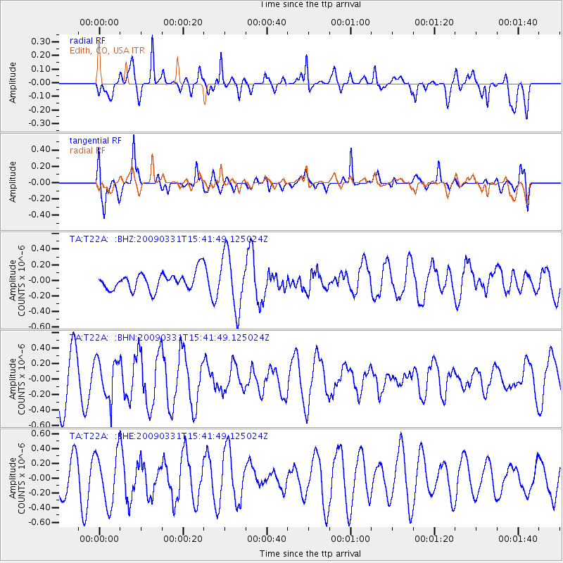
T22A Edith, CO, USA - Earthquake Result Viewer
*The percent match for this event was below the threshold and hence no stack was calculated.
| Earthquake location: |
Mariana Islands |
| Earthquake latitude/longitude: |
18.3/145.7 |
| Earthquake time(UTC): |
2009/03/31 (090) 15:29:31 GMT |
| Earthquake Depth: |
188 km |
| Earthquake Magnitude: |
5.5 MW, 5.4 MB, 5.4 MW |
| Earthquake Catalog/Contributor: |
WHDF/NEIC |
|
| Network: |
TA USArray Transportable Network (new EarthScope stations) |
| Station: |
T22A Edith, CO, USA |
| Lat/Lon: |
37.01 N/106.90 W |
| Elevation: |
2224 m |
|
| Distance: |
92.3 deg |
| Az: |
49.862 deg |
| Baz: |
294.861 deg |
| Ray Param: |
$rayparam |
*The percent match for this event was below the threshold and hence was not used in the summary stack. |
|
| Radial Match: |
68.31453 % |
| Radial Bump: |
400 |
| Transverse Match: |
68.84872 % |
| Transverse Bump: |
400 |
| SOD ConfigId: |
2658 |
| Insert Time: |
2010-03-06 00:01:46.558 +0000 |
| GWidth: |
2.5 |
| Max Bumps: |
400 |
| Tol: |
0.001 |
|
Signal To Noise
| Channel | StoN | STA | LTA |
| TA:T22A: :BHN:20090331T15:41:49.125024Z | 0.8900221 | 2.5733016E-7 | 2.8912783E-7 |
| TA:T22A: :BHE:20090331T15:41:49.125024Z | 1.212097 | 3.568752E-7 | 2.944279E-7 |
| TA:T22A: :BHZ:20090331T15:41:49.125024Z | 3.230995 | 3.5958635E-7 | 1.1129276E-7 |
| Arrivals |
| Ps | |
| PpPs | |
| PsPs/PpSs | |


