You are here: Home > Network List > GM - US Geological Survey Networks Stations List
> Station IWM01 Jericho 2M Well Monitoring Station > Earthquake Result Viewer
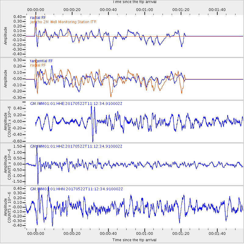
IWM01 Jericho 2M Well Monitoring Station - Earthquake Result Viewer
*The percent match for this event was below the threshold and hence no stack was calculated.
| Earthquake location: |
Kuril Islands |
| Earthquake latitude/longitude: |
43.9/147.7 |
| Earthquake time(UTC): |
2017/05/22 (142) 11:00:57 GMT |
| Earthquake Depth: |
54 km |
| Earthquake Magnitude: |
5.5 Mww |
| Earthquake Catalog/Contributor: |
NEIC PDE/us |
|
| Network: |
GM US Geological Survey Networks |
| Station: |
IWM01 Jericho 2M Well Monitoring Station |
| Lat/Lon: |
36.73 N/96.53 W |
| Elevation: |
328 m |
|
| Distance: |
80.8 deg |
| Az: |
47.14 deg |
| Baz: |
318.756 deg |
| Ray Param: |
$rayparam |
*The percent match for this event was below the threshold and hence was not used in the summary stack. |
|
| Radial Match: |
64.67215 % |
| Radial Bump: |
400 |
| Transverse Match: |
47.613094 % |
| Transverse Bump: |
400 |
| SOD ConfigId: |
13570011 |
| Insert Time: |
2019-04-28 01:49:51.417 +0000 |
| GWidth: |
2.5 |
| Max Bumps: |
400 |
| Tol: |
0.001 |
|
Signal To Noise
| Channel | StoN | STA | LTA |
| GM:IWM01:01:HHZ:20170522T11:12:34.910002Z | 7.8432503 | 6.248186E-7 | 7.966322E-8 |
| GM:IWM01:01:HHN:20170522T11:12:34.910002Z | 2.2282887 | 2.0439055E-7 | 9.172534E-8 |
| GM:IWM01:01:HHE:20170522T11:12:34.910002Z | 2.5314894 | 2.7213542E-7 | 1.0750012E-7 |
| Arrivals |
| Ps | |
| PpPs | |
| PsPs/PpSs | |


