You are here: Home > Network List > TA - USArray Transportable Network (new EarthScope stations) Stations List
> Station T22A Edith, CO, USA > Earthquake Result Viewer
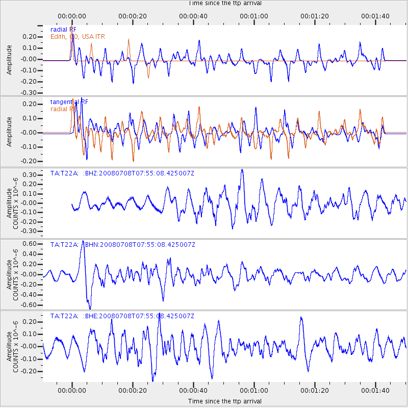
T22A Edith, CO, USA - Earthquake Result Viewer
*The percent match for this event was below the threshold and hence no stack was calculated.
| Earthquake location: |
Ryukyu Islands, Japan |
| Earthquake latitude/longitude: |
27.5/128.3 |
| Earthquake time(UTC): |
2008/07/08 (190) 07:42:10 GMT |
| Earthquake Depth: |
43 km |
| Earthquake Magnitude: |
6.0 MB, 5.5 MS, 6.0 MW, 6.0 MW |
| Earthquake Catalog/Contributor: |
WHDF/NEIC |
|
| Network: |
TA USArray Transportable Network (new EarthScope stations) |
| Station: |
T22A Edith, CO, USA |
| Lat/Lon: |
37.01 N/106.90 W |
| Elevation: |
2224 m |
|
| Distance: |
97.5 deg |
| Az: |
41.542 deg |
| Baz: |
312.631 deg |
| Ray Param: |
$rayparam |
*The percent match for this event was below the threshold and hence was not used in the summary stack. |
|
| Radial Match: |
68.19863 % |
| Radial Bump: |
400 |
| Transverse Match: |
63.811783 % |
| Transverse Bump: |
400 |
| SOD ConfigId: |
2504 |
| Insert Time: |
2010-03-06 00:01:58.744 +0000 |
| GWidth: |
2.5 |
| Max Bumps: |
400 |
| Tol: |
0.001 |
|
Signal To Noise
| Channel | StoN | STA | LTA |
| TA:T22A: :BHN:20080708T07:55:08.425007Z | 3.7468297 | 3.101824E-7 | 8.278529E-8 |
| TA:T22A: :BHE:20080708T07:55:08.425007Z | 1.2406055 | 9.317634E-8 | 7.510554E-8 |
| TA:T22A: :BHZ:20080708T07:55:08.425007Z | 1.8376801 | 8.902697E-8 | 4.8445305E-8 |
| Arrivals |
| Ps | |
| PpPs | |
| PsPs/PpSs | |


