You are here: Home > Network List > TA - USArray Transportable Network (new EarthScope stations) Stations List
> Station X28A Dimmitt, TX, USA > Earthquake Result Viewer
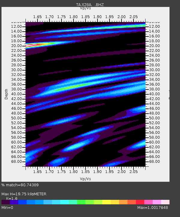
X28A Dimmitt, TX, USA - Earthquake Result Viewer
| Earthquake location: |
Near S. Coast Of Honshu, Japan |
| Earthquake latitude/longitude: |
33.2/137.9 |
| Earthquake time(UTC): |
2009/08/09 (221) 10:55:55 GMT |
| Earthquake Depth: |
297 km |
| Earthquake Magnitude: |
6.5 MB, 7.1 MW, 7.1 MW |
| Earthquake Catalog/Contributor: |
WHDF/NEIC |
|
| Network: |
TA USArray Transportable Network (new EarthScope stations) |
| Station: |
X28A Dimmitt, TX, USA |
| Lat/Lon: |
34.52 N/102.20 W |
| Elevation: |
1160 m |
|
| Distance: |
92.2 deg |
| Az: |
45.774 deg |
| Baz: |
313.288 deg |
| Ray Param: |
0.041323114 |
| Estimated Moho Depth: |
19.75 km |
| Estimated Crust Vp/Vs: |
1.60 |
| Assumed Crust Vp: |
6.242 km/s |
| Estimated Crust Vs: |
3.901 km/s |
| Estimated Crust Poisson's Ratio: |
0.18 |
|
| Radial Match: |
90.74389 % |
| Radial Bump: |
400 |
| Transverse Match: |
79.54844 % |
| Transverse Bump: |
400 |
| SOD ConfigId: |
2622 |
| Insert Time: |
2010-03-06 00:02:10.235 +0000 |
| GWidth: |
2.5 |
| Max Bumps: |
400 |
| Tol: |
0.001 |
|

Signal To Noise
| Channel | StoN | STA | LTA |
| TA:X28A: :BHZ:20090809T11:08:00.325027Z | 43.661934 | 5.5601568E-6 | 1.2734564E-7 |
| TA:X28A: :BHN:20090809T11:08:00.325027Z | 12.204376 | 1.0940976E-6 | 8.964797E-8 |
| TA:X28A: :BHE:20090809T11:08:00.325027Z | 13.98596 | 1.3306199E-6 | 9.513969E-8 |
| Arrivals |
| Ps | 1.9 SECOND |
| PpPs | 8.1 SECOND |
| PsPs/PpSs | 10.0 SECOND |


