You are here: Home > Network List > TA - USArray Transportable Network (new EarthScope stations) Stations List
> Station X28A Dimmitt, TX, USA > Earthquake Result Viewer
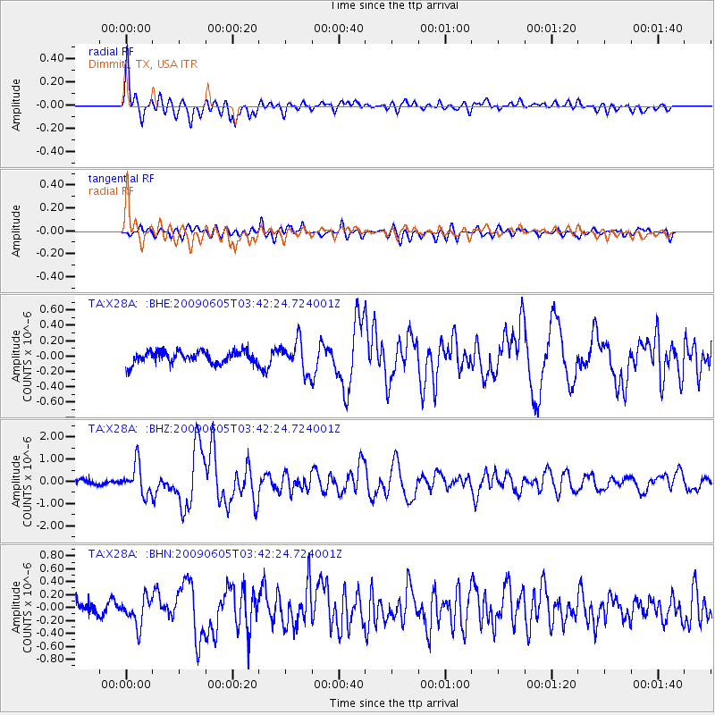
X28A Dimmitt, TX, USA - Earthquake Result Viewer

| Earthquake location: |
Hokkaido, Japan Region |
| Earthquake latitude/longitude: |
41.8/143.4 |
| Earthquake time(UTC): |
2009/06/05 (156) 03:30:33 GMT |
| Earthquake Depth: |
29 km |
| Earthquake Magnitude: |
6.0 MB, 6.3 MS, 6.4 MW, 6.4 MW |
| Earthquake Catalog/Contributor: |
WHDF/NEIC |
|
| Network: |
TA USArray Transportable Network (new EarthScope stations) |
| Station: |
X28A Dimmitt, TX, USA |
| Lat/Lon: |
34.52 N/102.20 W |
| Elevation: |
1160 m |
|
| Distance: |
83.1 deg |
| Az: |
49.263 deg |
| Baz: |
316.696 deg |
| Ray Param: |
0.046395145 |
| Estimated Moho Depth: |
34.25 km |
| Estimated Crust Vp/Vs: |
1.82 |
| Assumed Crust Vp: |
6.242 km/s |
| Estimated Crust Vs: |
3.425 km/s |
| Estimated Crust Poisson's Ratio: |
0.28 |
|
| Radial Match: |
89.61823 % |
| Radial Bump: |
400 |
| Transverse Match: |
75.74203 % |
| Transverse Bump: |
400 |
| SOD ConfigId: |
2648 |
| Insert Time: |
2010-03-06 00:02:22.471 +0000 |
| GWidth: |
2.5 |
| Max Bumps: |
400 |
| Tol: |
0.001 |
|
Signal To Noise
| Channel | StoN | STA | LTA |
| TA:X28A: :BHZ:20090605T03:42:24.724001Z | 7.3972235 | 6.8432325E-7 | 9.2510824E-8 |
| TA:X28A: :BHN:20090605T03:42:24.724001Z | 2.6015189 | 2.1573747E-7 | 8.292751E-8 |
| TA:X28A: :BHE:20090605T03:42:24.724001Z | 2.5210333 | 2.0296886E-7 | 8.051018E-8 |
| Arrivals |
| Ps | 4.6 SECOND |
| PpPs | 15 SECOND |
| PsPs/PpSs | 20 SECOND |


