You are here: Home > Network List > TA - USArray Transportable Network (new EarthScope stations) Stations List
> Station 833A Chaparral WMA, Artesia Wells, TX, USA > Earthquake Result Viewer
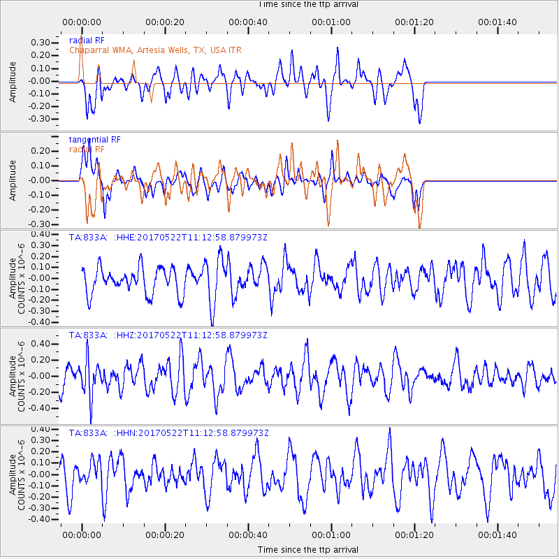
833A Chaparral WMA, Artesia Wells, TX, USA - Earthquake Result Viewer
*The percent match for this event was below the threshold and hence no stack was calculated.
| Earthquake location: |
Kuril Islands |
| Earthquake latitude/longitude: |
43.9/147.7 |
| Earthquake time(UTC): |
2017/05/22 (142) 11:00:57 GMT |
| Earthquake Depth: |
54 km |
| Earthquake Magnitude: |
5.5 Mww |
| Earthquake Catalog/Contributor: |
NEIC PDE/us |
|
| Network: |
TA USArray Transportable Network (new EarthScope stations) |
| Station: |
833A Chaparral WMA, Artesia Wells, TX, USA |
| Lat/Lon: |
28.32 N/99.39 W |
| Elevation: |
171 m |
|
| Distance: |
85.5 deg |
| Az: |
54.56 deg |
| Baz: |
318.106 deg |
| Ray Param: |
$rayparam |
*The percent match for this event was below the threshold and hence was not used in the summary stack. |
|
| Radial Match: |
48.054863 % |
| Radial Bump: |
400 |
| Transverse Match: |
45.32893 % |
| Transverse Bump: |
331 |
| SOD ConfigId: |
13570011 |
| Insert Time: |
2019-04-28 01:55:05.938 +0000 |
| GWidth: |
2.5 |
| Max Bumps: |
400 |
| Tol: |
0.001 |
|
Signal To Noise
| Channel | StoN | STA | LTA |
| TA:833A: :HHZ:20170522T11:12:58.879973Z | 1.5520351 | 2.1812228E-7 | 1.4053953E-7 |
| TA:833A: :HHN:20170522T11:12:58.879973Z | 0.47865003 | 9.101149E-8 | 1.9014203E-7 |
| TA:833A: :HHE:20170522T11:12:58.879973Z | 1.9054089 | 2.2212231E-7 | 1.1657461E-7 |
| Arrivals |
| Ps | |
| PpPs | |
| PsPs/PpSs | |


