You are here: Home > Network List > TA - USArray Transportable Network (new EarthScope stations) Stations List
> Station D23K Nanushuk River, AK USA > Earthquake Result Viewer
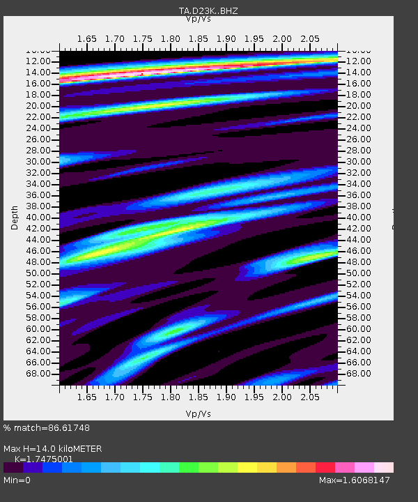
D23K Nanushuk River, AK USA - Earthquake Result Viewer
| Earthquake location: |
Kuril Islands |
| Earthquake latitude/longitude: |
43.9/147.7 |
| Earthquake time(UTC): |
2017/05/22 (142) 11:00:57 GMT |
| Earthquake Depth: |
54 km |
| Earthquake Magnitude: |
5.5 Mww |
| Earthquake Catalog/Contributor: |
NEIC PDE/us |
|
| Network: |
TA USArray Transportable Network (new EarthScope stations) |
| Station: |
D23K Nanushuk River, AK USA |
| Lat/Lon: |
68.97 N/150.68 W |
| Elevation: |
406 m |
|
| Distance: |
39.8 deg |
| Az: |
29.773 deg |
| Baz: |
263.632 deg |
| Ray Param: |
0.07464546 |
| Estimated Moho Depth: |
14.0 km |
| Estimated Crust Vp/Vs: |
1.75 |
| Assumed Crust Vp: |
6.221 km/s |
| Estimated Crust Vs: |
3.56 km/s |
| Estimated Crust Poisson's Ratio: |
0.26 |
|
| Radial Match: |
86.61748 % |
| Radial Bump: |
400 |
| Transverse Match: |
81.22999 % |
| Transverse Bump: |
400 |
| SOD ConfigId: |
13570011 |
| Insert Time: |
2019-04-28 01:55:13.270 +0000 |
| GWidth: |
2.5 |
| Max Bumps: |
400 |
| Tol: |
0.001 |
|

Signal To Noise
| Channel | StoN | STA | LTA |
| TA:D23K: :BHZ:20170522T11:07:55.075011Z | 20.211678 | 2.4945764E-6 | 1.2342252E-7 |
| TA:D23K: :BHN:20170522T11:07:55.075011Z | 3.8840427 | 3.268828E-7 | 8.416045E-8 |
| TA:D23K: :BHE:20170522T11:07:55.075011Z | 11.503643 | 1.0505134E-6 | 9.132006E-8 |
| Arrivals |
| Ps | 1.8 SECOND |
| PpPs | 5.8 SECOND |
| PsPs/PpSs | 7.6 SECOND |


