You are here: Home > Network List > TA - USArray Transportable Network (new EarthScope stations) Stations List
> Station X28A Dimmitt, TX, USA > Earthquake Result Viewer
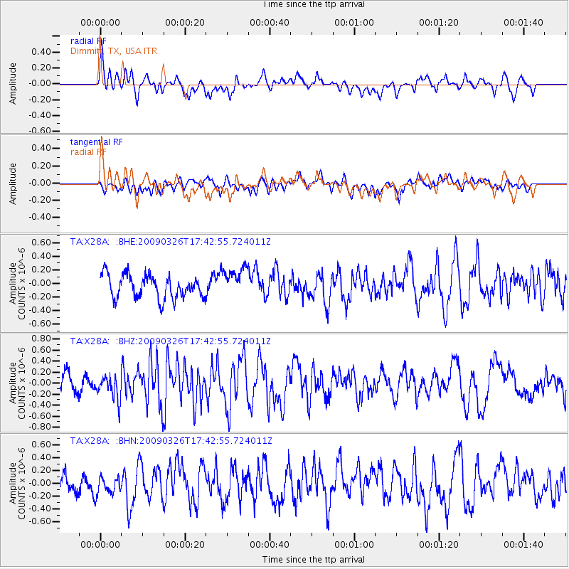
X28A Dimmitt, TX, USA - Earthquake Result Viewer
*The percent match for this event was below the threshold and hence no stack was calculated.
| Earthquake location: |
Near Coast Of Northern Peru |
| Earthquake latitude/longitude: |
-5.7/-81.3 |
| Earthquake time(UTC): |
2009/03/26 (085) 17:35:14 GMT |
| Earthquake Depth: |
10 km |
| Earthquake Magnitude: |
5.6 MB, 5.5 MS, 5.8 MW, 5.7 MW |
| Earthquake Catalog/Contributor: |
WHDF/NEIC |
|
| Network: |
TA USArray Transportable Network (new EarthScope stations) |
| Station: |
X28A Dimmitt, TX, USA |
| Lat/Lon: |
34.52 N/102.20 W |
| Elevation: |
1160 m |
|
| Distance: |
44.6 deg |
| Az: |
335.248 deg |
| Baz: |
149.697 deg |
| Ray Param: |
$rayparam |
*The percent match for this event was below the threshold and hence was not used in the summary stack. |
|
| Radial Match: |
65.74687 % |
| Radial Bump: |
400 |
| Transverse Match: |
53.52991 % |
| Transverse Bump: |
400 |
| SOD ConfigId: |
2658 |
| Insert Time: |
2010-03-06 00:03:22.779 +0000 |
| GWidth: |
2.5 |
| Max Bumps: |
400 |
| Tol: |
0.001 |
|
Signal To Noise
| Channel | StoN | STA | LTA |
| TA:X28A: :BHZ:20090326T17:42:55.724011Z | 1.4713867 | 2.1863359E-7 | 1.4859017E-7 |
| TA:X28A: :BHN:20090326T17:42:55.724011Z | 0.61932504 | 1.2521177E-7 | 2.0217458E-7 |
| TA:X28A: :BHE:20090326T17:42:55.724011Z | 1.3281009 | 2.2570268E-7 | 1.6994392E-7 |
| Arrivals |
| Ps | |
| PpPs | |
| PsPs/PpSs | |


