You are here: Home > Network List > TA - USArray Transportable Network (new EarthScope stations) Stations List
> Station F26K Sheenjek River, AK, USA > Earthquake Result Viewer
F26K Sheenjek River, AK, USA - Earthquake Result Viewer
| Earthquake location: |
Kuril Islands |
| Earthquake latitude/longitude: |
43.9/147.7 |
| Earthquake time(UTC): |
2017/05/22 (142) 11:00:57 GMT |
| Earthquake Depth: |
54 km |
| Earthquake Magnitude: |
5.5 Mww |
| Earthquake Catalog/Contributor: |
NEIC PDE/us |
|
| Network: |
TA USArray Transportable Network (new EarthScope stations) |
| Station: |
F26K Sheenjek River, AK, USA |
| Lat/Lon: |
67.69 N/144.15 W |
| Elevation: |
683 m |
|
| Distance: |
42.1 deg |
| Az: |
31.881 deg |
| Baz: |
271.294 deg |
| Ray Param: |
0.07321453 |
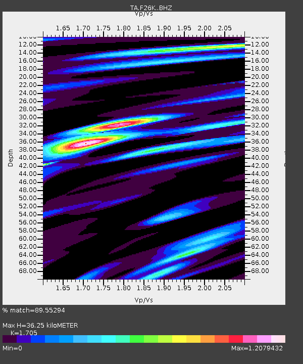
| Estimated Moho Depth: |
36.25 km |
| Estimated Crust Vp/Vs: |
1.71 |
| Assumed Crust Vp: |
6.522 km/s |
| Estimated Crust Vs: |
3.825 km/s |
| Estimated Crust Poisson's Ratio: |
0.24 |
|
| Radial Match: |
89.55294 % |
| Radial Bump: |
400 |
| Transverse Match: |
76.73477 % |
| Transverse Bump: |
400 |
| SOD ConfigId: |
13570011 |
| Insert Time: |
2019-04-28 01:55:24.570 +0000 |
| GWidth: |
2.5 |
| Max Bumps: |
400 |
| Tol: |
0.001 |
|
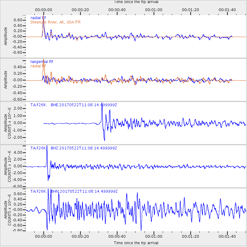
Signal To Noise
| Channel | StoN | STA | LTA |
| TA:F26K: :BHZ:20170522T11:08:14.499999Z | 25.414278 | 2.0815828E-6 | 8.190604E-8 |
| TA:F26K: :BHN:20170522T11:08:14.499999Z | 7.836404 | 3.4026934E-7 | 4.3421622E-8 |
| TA:F26K: :BHE:20170522T11:08:14.499999Z | 30.309679 | 1.051367E-6 | 3.46875E-8 |
| Arrivals |
| Ps | 4.2 SECOND |
| PpPs | 14 SECOND |
| PsPs/PpSs | 18 SECOND |


