You are here: Home > Network List > TA - USArray Transportable Network (new EarthScope stations) Stations List
> Station G30M túh Zraii Njik, YT, CAN > Earthquake Result Viewer
G30M túh Zraii Njik, YT, CAN - Earthquake Result Viewer
| Earthquake location: |
Kuril Islands |
| Earthquake latitude/longitude: |
43.9/147.7 |
| Earthquake time(UTC): |
2017/05/22 (142) 11:00:57 GMT |
| Earthquake Depth: |
54 km |
| Earthquake Magnitude: |
5.5 Mww |
| Earthquake Catalog/Contributor: |
NEIC PDE/us |
|
| Network: |
TA USArray Transportable Network (new EarthScope stations) |
| Station: |
G30M túh Zraii Njik, YT, CAN |
| Lat/Lon: |
66.98 N/136.22 W |
| Elevation: |
739 m |
|
| Distance: |
45.2 deg |
| Az: |
32.512 deg |
| Baz: |
279.057 deg |
| Ray Param: |
0.07125024 |
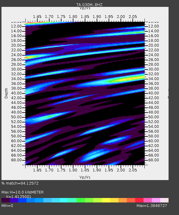
| Estimated Moho Depth: |
10.0 km |
| Estimated Crust Vp/Vs: |
1.61 |
| Assumed Crust Vp: |
6.522 km/s |
| Estimated Crust Vs: |
4.044 km/s |
| Estimated Crust Poisson's Ratio: |
0.19 |
|
| Radial Match: |
84.12572 % |
| Radial Bump: |
400 |
| Transverse Match: |
85.83101 % |
| Transverse Bump: |
400 |
| SOD ConfigId: |
13570011 |
| Insert Time: |
2019-04-28 01:55:32.202 +0000 |
| GWidth: |
2.5 |
| Max Bumps: |
400 |
| Tol: |
0.001 |
|

Signal To Noise
| Channel | StoN | STA | LTA |
| TA:G30M: :BHZ:20170522T11:08:39.524993Z | 23.733507 | 2.651831E-6 | 1.1173363E-7 |
| TA:G30M: :BHN:20170522T11:08:39.524993Z | 11.316944 | 1.12884E-6 | 9.974778E-8 |
| TA:G30M: :BHE:20170522T11:08:39.524993Z | 22.683493 | 1.9953673E-6 | 8.796562E-8 |
| Arrivals |
| Ps | 1.0 SECOND |
| PpPs | 3.7 SECOND |
| PsPs/PpSs | 4.7 SECOND |


