You are here: Home > Network List > TA - USArray Transportable Network (new EarthScope stations) Stations List
> Station L20K Farewell, AK, USA > Earthquake Result Viewer
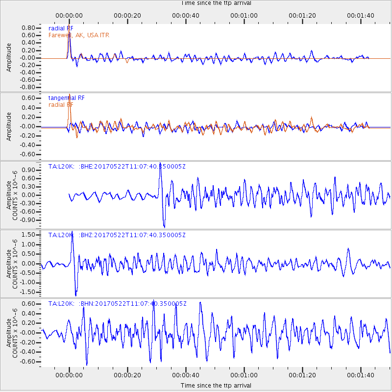
L20K Farewell, AK, USA - Earthquake Result Viewer
*The percent match for this event was below the threshold and hence no stack was calculated.
| Earthquake location: |
Kuril Islands |
| Earthquake latitude/longitude: |
43.9/147.7 |
| Earthquake time(UTC): |
2017/05/22 (142) 11:00:57 GMT |
| Earthquake Depth: |
54 km |
| Earthquake Magnitude: |
5.5 Mww |
| Earthquake Catalog/Contributor: |
NEIC PDE/us |
|
| Network: |
TA USArray Transportable Network (new EarthScope stations) |
| Station: |
L20K Farewell, AK, USA |
| Lat/Lon: |
62.48 N/153.88 W |
| Elevation: |
673 m |
|
| Distance: |
38.0 deg |
| Az: |
39.993 deg |
| Baz: |
268.681 deg |
| Ray Param: |
$rayparam |
*The percent match for this event was below the threshold and hence was not used in the summary stack. |
|
| Radial Match: |
73.01911 % |
| Radial Bump: |
400 |
| Transverse Match: |
54.37429 % |
| Transverse Bump: |
400 |
| SOD ConfigId: |
13570011 |
| Insert Time: |
2019-04-28 01:55:52.354 +0000 |
| GWidth: |
2.5 |
| Max Bumps: |
400 |
| Tol: |
0.001 |
|
Signal To Noise
| Channel | StoN | STA | LTA |
| TA:L20K: :BHZ:20170522T11:07:40.350005Z | 7.2783046 | 7.782748E-7 | 1.0693078E-7 |
| TA:L20K: :BHN:20170522T11:07:40.350005Z | 1.8706068 | 1.899564E-7 | 1.01548004E-7 |
| TA:L20K: :BHE:20170522T11:07:40.350005Z | 5.784334 | 5.468988E-7 | 9.454826E-8 |
| Arrivals |
| Ps | |
| PpPs | |
| PsPs/PpSs | |


