You are here: Home > Network List > TA - USArray Transportable Network (new EarthScope stations) Stations List
> Station M31M Drury Creek, Yukon, CA > Earthquake Result Viewer
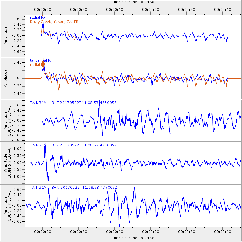
M31M Drury Creek, Yukon, CA - Earthquake Result Viewer
*The percent match for this event was below the threshold and hence no stack was calculated.
| Earthquake location: |
Kuril Islands |
| Earthquake latitude/longitude: |
43.9/147.7 |
| Earthquake time(UTC): |
2017/05/22 (142) 11:00:57 GMT |
| Earthquake Depth: |
54 km |
| Earthquake Magnitude: |
5.5 Mww |
| Earthquake Catalog/Contributor: |
NEIC PDE/us |
|
| Network: |
TA USArray Transportable Network (new EarthScope stations) |
| Station: |
M31M Drury Creek, Yukon, CA |
| Lat/Lon: |
62.20 N/134.39 W |
| Elevation: |
639 m |
|
| Distance: |
47.0 deg |
| Az: |
38.792 deg |
| Baz: |
285.065 deg |
| Ray Param: |
$rayparam |
*The percent match for this event was below the threshold and hence was not used in the summary stack. |
|
| Radial Match: |
58.80899 % |
| Radial Bump: |
400 |
| Transverse Match: |
60.175606 % |
| Transverse Bump: |
400 |
| SOD ConfigId: |
13570011 |
| Insert Time: |
2019-04-28 01:56:08.373 +0000 |
| GWidth: |
2.5 |
| Max Bumps: |
400 |
| Tol: |
0.001 |
|
Signal To Noise
| Channel | StoN | STA | LTA |
| TA:M31M: :BHZ:20170522T11:08:53.475005Z | 4.0604544 | 6.1186586E-7 | 1.5068902E-7 |
| TA:M31M: :BHN:20170522T11:08:53.475005Z | 1.3450892 | 2.2439079E-7 | 1.6682225E-7 |
| TA:M31M: :BHE:20170522T11:08:53.475005Z | 2.0243132 | 3.080343E-7 | 1.521673E-7 |
| Arrivals |
| Ps | |
| PpPs | |
| PsPs/PpSs | |


