You are here: Home > Network List > TA - USArray Transportable Network (new EarthScope stations) Stations List
> Station R33M Jennings River, BC, CAN > Earthquake Result Viewer
R33M Jennings River, BC, CAN - Earthquake Result Viewer
*The percent match for this event was below the threshold and hence no stack was calculated.
| Earthquake location: |
Kuril Islands |
| Earthquake latitude/longitude: |
43.9/147.7 |
| Earthquake time(UTC): |
2017/05/22 (142) 11:00:57 GMT |
| Earthquake Depth: |
54 km |
| Earthquake Magnitude: |
5.5 Mww |
| Earthquake Catalog/Contributor: |
NEIC PDE/us |
|
| Network: |
TA USArray Transportable Network (new EarthScope stations) |
| Station: |
R33M Jennings River, BC, CAN |
| Lat/Lon: |
59.39 N/130.97 W |
| Elevation: |
1437 m |
|
| Distance: |
49.5 deg |
| Az: |
41.714 deg |
| Baz: |
289.996 deg |
| Ray Param: |
$rayparam |
*The percent match for this event was below the threshold and hence was not used in the summary stack. |
|
| Radial Match: |
44.78593 % |
| Radial Bump: |
400 |
| Transverse Match: |
66.951164 % |
| Transverse Bump: |
400 |
| SOD ConfigId: |
13570011 |
| Insert Time: |
2019-04-28 01:56:42.924 +0000 |
| GWidth: |
2.5 |
| Max Bumps: |
400 |
| Tol: |
0.001 |
|
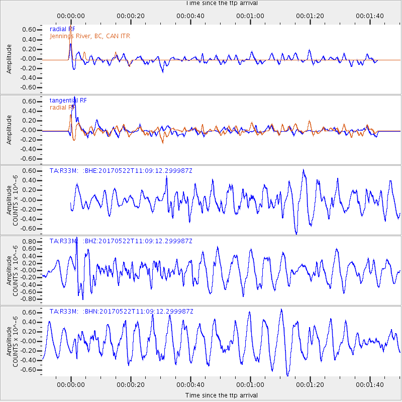
Signal To Noise
| Channel | StoN | STA | LTA |
| TA:R33M: :BHZ:20170522T11:09:12.299987Z | 2.3646402 | 4.4885462E-7 | 1.898194E-7 |
| TA:R33M: :BHN:20170522T11:09:12.299987Z | 0.8705156 | 1.5108603E-7 | 1.7355924E-7 |
| TA:R33M: :BHE:20170522T11:09:12.299987Z | 1.3829463 | 1.911302E-7 | 1.3820508E-7 |
| Arrivals |
| Ps | |
| PpPs | |
| PsPs/PpSs | |


