You are here: Home > Network List > UW - Pacific Northwest Regional Seismic Network Stations List
> Station UMAT Pilot Rock, OR, USA > Earthquake Result Viewer
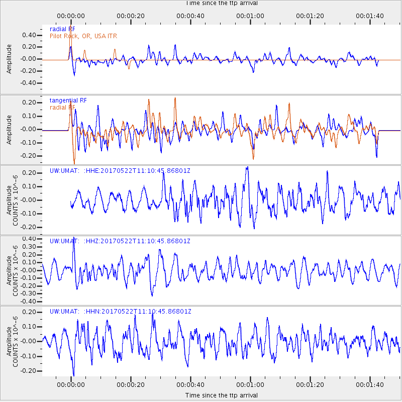
UMAT Pilot Rock, OR, USA - Earthquake Result Viewer
*The percent match for this event was below the threshold and hence no stack was calculated.
| Earthquake location: |
Kuril Islands |
| Earthquake latitude/longitude: |
43.9/147.7 |
| Earthquake time(UTC): |
2017/05/22 (142) 11:00:57 GMT |
| Earthquake Depth: |
54 km |
| Earthquake Magnitude: |
5.5 Mww |
| Earthquake Catalog/Contributor: |
NEIC PDE/us |
|
| Network: |
UW Pacific Northwest Regional Seismic Network |
| Station: |
UMAT Pilot Rock, OR, USA |
| Lat/Lon: |
45.29 N/118.96 W |
| Elevation: |
1318 m |
|
| Distance: |
62.6 deg |
| Az: |
52.535 deg |
| Baz: |
305.662 deg |
| Ray Param: |
$rayparam |
*The percent match for this event was below the threshold and hence was not used in the summary stack. |
|
| Radial Match: |
53.82057 % |
| Radial Bump: |
400 |
| Transverse Match: |
56.841686 % |
| Transverse Bump: |
400 |
| SOD ConfigId: |
13570011 |
| Insert Time: |
2019-04-28 01:57:44.296 +0000 |
| GWidth: |
2.5 |
| Max Bumps: |
400 |
| Tol: |
0.001 |
|
Signal To Noise
| Channel | StoN | STA | LTA |
| UW:UMAT: :HHZ:20170522T11:10:45.86801Z | 1.7898091 | 1.5313958E-7 | 8.5561965E-8 |
| UW:UMAT: :HHN:20170522T11:10:45.86801Z | 1.6148218 | 1.0124334E-7 | 6.2696294E-8 |
| UW:UMAT: :HHE:20170522T11:10:45.86801Z | 1.5799333 | 8.267431E-8 | 5.2327728E-8 |
| Arrivals |
| Ps | |
| PpPs | |
| PsPs/PpSs | |


