You are here: Home > Network List > TJ - Tajikistan National Seismic Network Stations List
> Station GARM Garm, Tajikistan > Earthquake Result Viewer
GARM Garm, Tajikistan - Earthquake Result Viewer
| Earthquake location: |
Sulawesi, Indonesia |
| Earthquake latitude/longitude: |
-2.8/122.2 |
| Earthquake time(UTC): |
2017/05/24 (144) 09:10:15 GMT |
| Earthquake Depth: |
15 km |
| Earthquake Magnitude: |
5.6 Mww |
| Earthquake Catalog/Contributor: |
NEIC PDE/us |
|
| Network: |
TJ Tajikistan National Seismic Network |
| Station: |
GARM Garm, Tajikistan |
| Lat/Lon: |
39.00 N/70.32 E |
| Elevation: |
1305 m |
|
| Distance: |
63.2 deg |
| Az: |
316.654 deg |
| Baz: |
118.371 deg |
| Ray Param: |
0.059716538 |
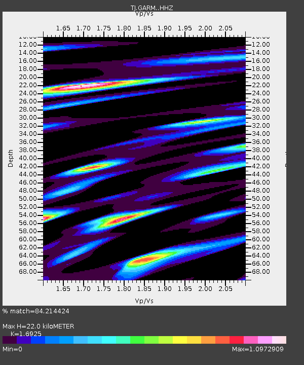
| Estimated Moho Depth: |
22.0 km |
| Estimated Crust Vp/Vs: |
1.69 |
| Assumed Crust Vp: |
6.306 km/s |
| Estimated Crust Vs: |
3.726 km/s |
| Estimated Crust Poisson's Ratio: |
0.23 |
|
| Radial Match: |
84.214424 % |
| Radial Bump: |
400 |
| Transverse Match: |
74.83202 % |
| Transverse Bump: |
400 |
| SOD ConfigId: |
13570011 |
| Insert Time: |
2019-04-28 02:01:54.362 +0000 |
| GWidth: |
2.5 |
| Max Bumps: |
400 |
| Tol: |
0.001 |
|
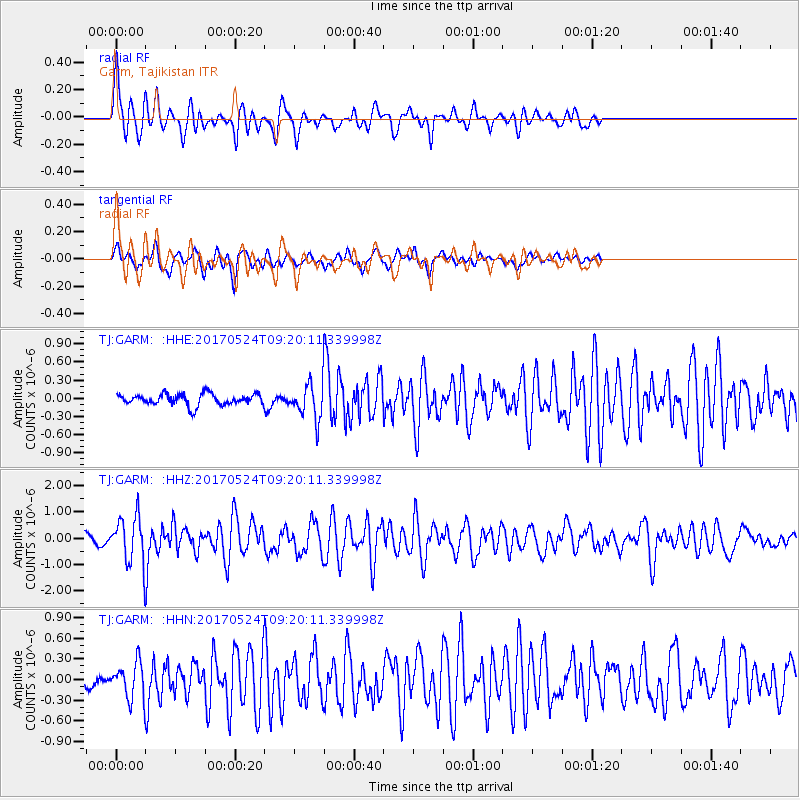
Signal To Noise
| Channel | StoN | STA | LTA |
| TJ:GARM: :HHZ:20170524T09:20:11.339998Z | 7.8326597 | 9.4042775E-7 | 1.2006494E-7 |
| TJ:GARM: :HHN:20170524T09:20:11.339998Z | 2.880496 | 2.7535097E-7 | 9.559152E-8 |
| TJ:GARM: :HHE:20170524T09:20:11.339998Z | 3.9843314 | 3.766869E-7 | 9.454206E-8 |
| Arrivals |
| Ps | 2.5 SECOND |
| PpPs | 9.0 SECOND |
| PsPs/PpSs | 12 SECOND |


