You are here: Home > Network List > IW - Intermountain West Stations List
> Station MOOW Moose Ponds, Wyoming, USA > Earthquake Result Viewer
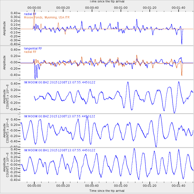
MOOW Moose Ponds, Wyoming, USA - Earthquake Result Viewer
*The percent match for this event was below the threshold and hence no stack was calculated.
| Earthquake location: |
Near Coast Of Central Chile |
| Earthquake latitude/longitude: |
-30.8/-71.7 |
| Earthquake time(UTC): |
2015/12/08 (342) 12:56:07 GMT |
| Earthquake Depth: |
30 km |
| Earthquake Magnitude: |
5.6 MB |
| Earthquake Catalog/Contributor: |
NEIC PDE/NEIC COMCAT |
|
| Network: |
IW Intermountain West |
| Station: |
MOOW Moose Ponds, Wyoming, USA |
| Lat/Lon: |
43.75 N/110.74 W |
| Elevation: |
2128 m |
|
| Distance: |
82.3 deg |
| Az: |
332.597 deg |
| Baz: |
146.87 deg |
| Ray Param: |
$rayparam |
*The percent match for this event was below the threshold and hence was not used in the summary stack. |
|
| Radial Match: |
49.436153 % |
| Radial Bump: |
400 |
| Transverse Match: |
60.185074 % |
| Transverse Bump: |
400 |
| SOD ConfigId: |
1259291 |
| Insert Time: |
2015-12-22 13:04:04.243 +0000 |
| GWidth: |
2.5 |
| Max Bumps: |
400 |
| Tol: |
0.001 |
|
Signal To Noise
| Channel | StoN | STA | LTA |
| IW:MOOW:00:BHZ:20151208T13:07:55.445012Z | 2.2818544 | 3.399276E-7 | 1.4896989E-7 |
| IW:MOOW:00:BH1:20151208T13:07:55.445012Z | 1.0203099 | 1.451374E-7 | 1.4224835E-7 |
| IW:MOOW:00:BH2:20151208T13:07:55.445012Z | 1.3821281 | 1.1143239E-7 | 8.062378E-8 |
| Arrivals |
| Ps | |
| PpPs | |
| PsPs/PpSs | |


