You are here: Home > Network List > TA - USArray Transportable Network (new EarthScope stations) Stations List
> Station D23K Nanushuk River, AK USA > Earthquake Result Viewer
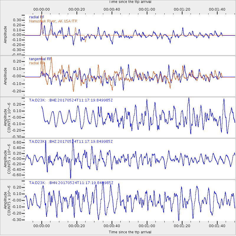
D23K Nanushuk River, AK USA - Earthquake Result Viewer
*The percent match for this event was below the threshold and hence no stack was calculated.
| Earthquake location: |
Solomon Islands |
| Earthquake latitude/longitude: |
-10.0/161.9 |
| Earthquake time(UTC): |
2017/05/24 (144) 11:05:19 GMT |
| Earthquake Depth: |
55 km |
| Earthquake Magnitude: |
5.5 Mww |
| Earthquake Catalog/Contributor: |
NEIC PDE/us |
|
| Network: |
TA USArray Transportable Network (new EarthScope stations) |
| Station: |
D23K Nanushuk River, AK USA |
| Lat/Lon: |
68.97 N/150.68 W |
| Elevation: |
406 m |
|
| Distance: |
85.5 deg |
| Az: |
15.478 deg |
| Baz: |
226.723 deg |
| Ray Param: |
$rayparam |
*The percent match for this event was below the threshold and hence was not used in the summary stack. |
|
| Radial Match: |
68.79492 % |
| Radial Bump: |
400 |
| Transverse Match: |
56.87368 % |
| Transverse Bump: |
400 |
| SOD ConfigId: |
13570011 |
| Insert Time: |
2019-04-28 02:06:04.904 +0000 |
| GWidth: |
2.5 |
| Max Bumps: |
400 |
| Tol: |
0.001 |
|
Signal To Noise
| Channel | StoN | STA | LTA |
| TA:D23K: :BHZ:20170524T11:17:19.849985Z | 2.207328 | 2.1841275E-7 | 9.8948924E-8 |
| TA:D23K: :BHN:20170524T11:17:19.849985Z | 1.4137558 | 1.3716455E-7 | 9.702139E-8 |
| TA:D23K: :BHE:20170524T11:17:19.849985Z | 1.1130215 | 9.536696E-8 | 8.568294E-8 |
| Arrivals |
| Ps | |
| PpPs | |
| PsPs/PpSs | |


