You are here: Home > Network List > TA - USArray Transportable Network (new EarthScope stations) Stations List
> Station J20K Nowitna River, AK, USA > Earthquake Result Viewer
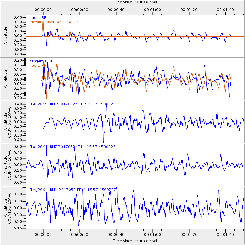
J20K Nowitna River, AK, USA - Earthquake Result Viewer
*The percent match for this event was below the threshold and hence no stack was calculated.
| Earthquake location: |
Solomon Islands |
| Earthquake latitude/longitude: |
-10.0/161.9 |
| Earthquake time(UTC): |
2017/05/24 (144) 11:05:19 GMT |
| Earthquake Depth: |
55 km |
| Earthquake Magnitude: |
5.5 Mww |
| Earthquake Catalog/Contributor: |
NEIC PDE/us |
|
| Network: |
TA USArray Transportable Network (new EarthScope stations) |
| Station: |
J20K Nowitna River, AK, USA |
| Lat/Lon: |
64.18 N/154.15 W |
| Elevation: |
314 m |
|
| Distance: |
81.1 deg |
| Az: |
17.935 deg |
| Baz: |
223.832 deg |
| Ray Param: |
$rayparam |
*The percent match for this event was below the threshold and hence was not used in the summary stack. |
|
| Radial Match: |
46.10895 % |
| Radial Bump: |
375 |
| Transverse Match: |
36.929092 % |
| Transverse Bump: |
371 |
| SOD ConfigId: |
13570011 |
| Insert Time: |
2019-04-28 02:06:24.974 +0000 |
| GWidth: |
2.5 |
| Max Bumps: |
400 |
| Tol: |
0.001 |
|
Signal To Noise
| Channel | StoN | STA | LTA |
| TA:J20K: :BHZ:20170524T11:16:57.450022Z | 3.439534 | 2.1929155E-7 | 6.375618E-8 |
| TA:J20K: :BHN:20170524T11:16:57.450022Z | 1.6521201 | 9.766138E-8 | 5.911276E-8 |
| TA:J20K: :BHE:20170524T11:16:57.450022Z | 2.8962204 | 1.9528763E-7 | 6.742844E-8 |
| Arrivals |
| Ps | |
| PpPs | |
| PsPs/PpSs | |


